


- Region
- Texas
- Country
- United States
- Best for
- fly fishing, fishing
- Best season
- Spring, Summer
- Permits
- Check TPWD fishing license requirements an…
- Managed by
- ACND manages Cove Harbor; TPWD regulates fishing. Island land manager not confirmed.
Plan with verified data
Traylor Island, Aransas Bay trip tools
Tools for a trip here
Picked for how, when and where you're going. Free, no signup.
Photos of Traylor Island, Aransas Bay
How to get there
Cove Harbor in Rockport is a verified mainland launch facility. ACND publishes its harbor reference at 27.989799 N, -97.072798 W and lists North and South Boat Ramps, restrooms and overnight parking. Use directions to Cove Harbor, not driving directions to the island pin. Confirm the appropriate road entrance, ramp, parking rules and any current charges with ACND before arriving. The island has no verified road access or public landing. No fixed paddle distance or safe channel route is asserted: plan the water approach with current marine charts, weather, water levels and local knowledge.
- Cove Harbor, Rockport
Official ACND facility with North and South Boat Ramps, restrooms and overnight parking listed. This is the harbor reference, not a particular ramp mouth. Confirm entrance, ramp status and charges before arrival; launch access is not island landing permission.
Sources: TopoQuest, USGS-derived data · Aransas County Navigation District · Texas Parks and Wildlife Department · Texas Parks and Wildlife Department. Confirm road and trailhead conditions with the managing agency before you leave.
Texas · United States · Season: Weather-dependent year-round bay outings; spring and autumn for milder conditions
- Fishing
- Sea Kayaking
- Beachcombing
- Photography
An island destination, not a public campground
Traylor Island is a named low-lying island in Aransas County, Texas, beside the Estes Flats fishing waters in the Aransas Bay setting. The USGS-derived geographic record gives 27.949466 N, -97.072489 W on the Estes quadrangle. This pin identifies the island, not a dock, safe landing or route through the shallows.
Land access is not established
2020 news reporting described Traylor Island as private property offered for sale. Its current owner and any public landing agreement remain unverified. No official public campground, reservable campsite or island-specific public access policy was found. Arrange any landing or overnight stay with the owner or appropriate authority first. A public mainland boat launch does not grant permission to enter island land.
Plan a bay fishing outing
Estes Flats and the waters near Traylor Island appear in regional redfish and trout fishing coverage. That is regional fishing context, not a promise of a catch at this pin. Wind, water level, clarity, boat traffic and current fishing rules decide whether a day is suitable. Choose a locally knowledgeable guide if you cannot confidently navigate shallow coastal water. The island’s lee is not guaranteed shelter if the wind changes.
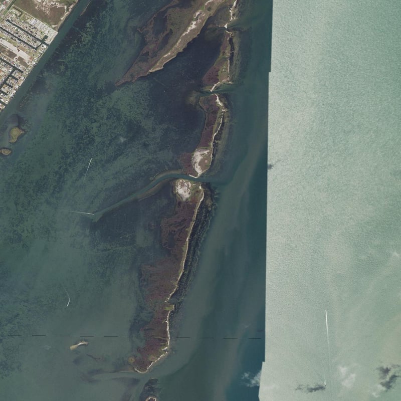
A real aerial photo of this island
The cover is real USGS / USDA National Map NAIP Plus aerial orthoimagery exported around the verified island location. It shows the island shoreline and surrounding shallows, not a generated image or an unrelated destination. Acquisition seams are visible; the acquisition date is not established here. This photograph is not a live image or navigational chart.
Field notes
- Use the Cove Harbor harbor reference to find the mainland facility; confirm the appropriate ramp and parking arrangements with ACND before travelling.
- Check the marine forecast and tide information, then set a conservative return time and leave a shore contact your plan.
- No public island landing or camping permission has been verified; keep a bay fishing trip separate from permission to enter private land.
- Protect seagrass, and check the Redfish Bay State Scientific Area boundary if your outing extends into those regulated waters.
Where on earth
Satellite imagery flying in from a world view to Traylor Island, Aransas Bay, United States. Use the + / − buttons, or click the map to zoom with your scroll wheel; drag to pan and pinch to zoom on touch.
Coordinates
- Decimal degrees
- 27.9495, -97.0725
- Latitude (DMS)
- 27° 56′ 58.1″ N
- Longitude (DMS)
- 97° 4′ 21.0″ W
Coordinates are an access-point reference for Traylor Island, Aransas Bay, not a route. Carry a paper map and confirm trailhead or put-in access with the managing agency before you go.
Topic summary
Bay fishing beside Estes Flats, verified Cove Harbor launch information and careful planning for private-land access.
Key takeaways
- Region: Texas
- Country: United States
- Best season: Weather-dependent year-round bay outings; spring and autumn for milder conditions
- Good for: fly fishing, fishing
- Coordinates: 27.949, -97.072
Intended uses
- fly fishing
- fishing
Climate suitability
Weather-dependent year-round bay outings; spring and autumn for milder conditions
Keep planning
Popular pursuits at Traylor Island, Aransas Bay
- Fishing
Resident gamefish, seasons, and the water that holds them.
- Sea Kayaking
Coastal crossings, tides, and protected camps.
- Beachcombing
Tide-line walking between camps.
- Photography
Vantage points and the hours worth setting an alarm for.
Animals around Traylor Island, Aransas Bay



An island destination, not a public campground
Traylor Island is a named low-lying island in Aransas County, Texas, beside the Estes Flats fishing waters in the Aransas Bay setting. The USGS-derived geographic record gives 27.949466 N, -97.072489 W on the Estes quadrangle. This pin identifies the island, not a dock, safe landing or route through the shallows.
Land access is not established
2020 news reporting described Traylor Island as private property offered for sale. Its current owner and any public landing agreement remain unverified. No official public campground, reservable campsite or island-specific public access policy was found. Arrange any landing or overnight stay with the owner or appropriate authority first. A public mainland boat launch does not grant permission to enter island land.
Sample itineraries
- Weather-dependent bay fishing day · 1 day
Check fishing rules, marine weather and tides before travelling to Cove Harbor. Confirm the launch and parking arrangements with ACND. Fish suitable bay water within your navigation and boat-handling ability, or arrange a local guide. Do not plan an island landing without permission; return before conditions deteriorate. No surveyed route or fixed distance is provided.
Seasonal conditions
Spring
March–May
A general planning window for milder Gulf Coast conditions, not a guaranteed fish run or opening. Check fronts, wind, clarity and the marine forecast.
Summer
June–August
Plan around heat and thunderstorms. Atlantic hurricane season runs June through November; check tropical advisories as well as the local marine forecast.
Autumn
September–November
Potentially milder outings, but tropical weather remains possible through November and fronts can change conditions. No island-specific fishing opening is asserted.
Winter
December–February
Cold fronts can bring strong winds and cold-water hazards. Choose conservative weather windows and check any TPWD emergency restrictions. Regional year-round interest does not mean safe access every day.
| Season | Window | Conditions |
|---|---|---|
| Spring | March–May | A general planning window for milder Gulf Coast conditions, not a guaranteed fish run or opening. Check fronts, wind, clarity and the marine forecast. |
| Summer | June–August | Plan around heat and thunderstorms. Atlantic hurricane season runs June through November; check tropical advisories as well as the local marine forecast. |
| Autumn | September–November | Potentially milder outings, but tropical weather remains possible through November and fronts can change conditions. No island-specific fishing opening is asserted. |
| Winter | December–February | Cold fronts can bring strong winds and cold-water hazards. Choose conservative weather windows and check any TPWD emergency restrictions. Regional year-round interest does not mean safe access every day. |
Permits, fees & closures
Check TPWD fishing license requirements and exemptions, including saltwater endorsement requirements for coastal fishing, and current species bag, size and tag rules. No island landing or camping permission has been verified. Confirm launch and parking charges with ACND; no price is quoted.
Official source: ACND — Cove Harbor · Verified October 9, 2026
Hazards & regulations
- Wind shifts, thunderstorms and tropical weather can make the return unsafe. Check marine forecasts and carry communication equipment.
- Shallows, seagrass and boat traffic require current charts and local knowledge; the island pin is not a navigable route.
- Wear an appropriate personal flotation device, carry drinking water and sun protection, and use cold-water protection when needed.
- Uprooting seagrass with a submerged propeller is prohibited in Redfish Bay State Scientific Area. Verify the regulated boundary if going there; this is not a claim that the island itself is inside it.
- Island land access and camping permission remain unverified; do not enter private land based on this guide.
What to pack for Traylor Island, Aransas Bay
- Appropriate personal flotation device worn on the water
- Current marine chart and offline navigation
- Waterproof communication equipment
- Weather and tide check; return plan with a shore contact
- Current license and saltwater endorsement if required
- Coastal fishing or fly-fishing outfit
- Pliers and safe hook-removal equipment
- Drinking water, sun protection and first aid
- Cold-water protection when needed
Traylor Island, Aransas Bay FAQ
- Where is Traylor Island?
- In Aransas County, Texas, beside Estes Flats in the Aransas Bay setting. Its USGS-derived island reference is 27.949466, -97.072489, not a launch or landing.
- Where can I launch?
- ACND lists Cove Harbor in Rockport with North and South Boat Ramps. Confirm the entrance, appropriate ramp and current parking arrangements before arriving.
- Can I camp on Traylor Island?
- No public island camping permission has been verified. Reporting described private ownership; do not land or camp without permission from the current owner or appropriate authority.
- Is the cover a real photograph?
- Yes, public-domain USGS / USDA aerial photography of this island and surrounding shallows, not generated art or another destination. It is not a current navigation chart.
- Does the pin show a safe boat route?
- No. It identifies the named island feature only. Use current charts, local knowledge and suitable conditions; this guide does not invent a route through the shallows.