


Reader rating
Rate it and you move it. Community ratings re-rank this product inside its Top 10 list.
Expert-picked, reader-ranked. Our editors choose the products and the launch order; member star ratings move picks up or down over time.
Wildflowers linger and high routes like the Wonderland are snow-free.
Pros
- Prime summer window for snow-free alpine and subalpine trail travel
- Spectacular subalpine wildflower blooms peaking across meadow basins
- Most stable, sunny, and predictable weather conditions of the year
- Full access to high-elevation Wonderland Trail passes and alpine camps
Cons
- High visitor volume requires competitive timed-entry vehicle reservations
- Backcountry wilderness camping permits are exceptionally difficult to secure
- Aggressive biting flies and mosquitoes can be intense near snowmelt and tarns
Best uses
- Full Wonderland Trail backpacking
- High-elevation day hiking
- Subalpine wildflower photography
- Glacier-view trail running
Specifications
- Location
- Pierce and Lewis Counties, Washington
- Elevation Range
- 1,880 to 14,410 feet
- Peak Season
- Late July through early September
- Major Route
- Wonderland Trail (93 miles)
- Vehicle Access
- Timed-entry reservation required during peak hours
- Park Size
- Approximately 236,381 acres
Best for
Full Wonderland Trail backpacking, High-elevation day hiking, Subalpine wildflower photography, Glacier-view trail running
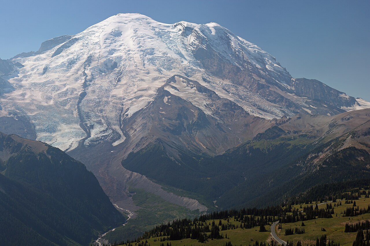
August is the razor-thin sweet spot for the Pacific Northwest's crowning volcano. The persistent winter snowpack that chokes high ridgelines well into July finally pulls back, exposing subalpine meadows and rocky passes that spend ten months buried in white. This is the short, glorious window when the peak shifts from a purely technical mountaineering objective to premier hiking territory. The terrain is dramatic and uncompromising, rising from temperate river valleys below 2,000 feet to an icy 14,410-foot summit covered in active glaciers. In August, high meadows around Paradise, Sunrise, and Spray Park explode with vibrant wildflowers, while the 93-mile Wonderland Trail finally clears of snow bridge hazards. Stable high-pressure systems bring crisp, clear skies, giving trail runners, backpackers, and day hikers unobstructed views across the southern Cascades. The price of admission is relentless crowds and strict bureaucracy. Recent years have brought timed-entry vehicle reservations to manage the crush at popular trailheads, and backcountry camps book out months in advance. Yet for those willing to wake up before dawn and haul a pack into the subalpine backcountry, late summer around the mountain is unmatched.
Terrain and Alpine Geography
The topography here is dictated entirely by volcanic mass and glacial ice. Twenty-five major glaciers grind down the flanks of the mountain, feeding rushing glacial rivers that slice deep canyons into the surrounding evergreen forests. Moving up from the valley floor takes you through old-growth western redcedar and hemlock before breaking out into steep heather meadows around 5,000 feet. Above the tree line, the terrain shifts abruptly to loose volcanic scree, crumbling pumice, and permanent icefields. Foot travel requires strong knees and reliable footwear, as steep switchbacks and relentless vertical changes are standard on virtually every trail. The proximity of ancient rainforests to freezing glacial moraines creates distinct microclimates, where sunny valley bottoms can quickly give way to bitter alpine winds within a few thousand feet of climbing.
The August Weather Window
Pacific Northwest summers are famously short, and August represents the most dependable weather window of the entire calendar year. Pacific high-pressure systems typically settle over western Washington, bringing prolonged stretches of dry, sunny days with daytime temperatures in the 60s and 70s at mid-elevations. However, mountain weather is inherently volatile. Thunderstorms can bubble up along ridgelines on hot afternoons, and sudden marine layers occasionally sweep in from Puget Sound to shroud peaks in freezing fog. Nighttime temperatures in high-elevation backcountry camps routinely dip toward freezing, even during heatwaves down in Seattle. Snowfields persist on northern exposures and high cols like Panhandle Gap throughout the month, requiring careful route awareness and sturdy boots. Preparation for sudden temperature drops remains mandatory.
Flora and Subalpine Wildlife
August transforms the park's subalpine zones into botanical marvels. Peak bloom hits between late July and mid-August, cloaking valleys in subalpine lupine, scarlet paintbrush, magenta paintbrush, and glacier lilies. This explosive vegetation supports an active wildlife community scrambling to feed before the return of winter. Hoary marmots whistle warning calls from talus slopes, while pikas scurry among rocks drying winter vegetation. Cascade golden-mantled ground squirrels patrol campsites, and black bears frequent avalanche shoots to forage on wild berries and roots. Mountain goats are common sights along rugged ridgelines near Sunrise and Mount Fremont. Encounters with wildlife require firm adherence to food storage rules; bears are habituated to trail corridors, making bear canisters mandatory for backpackers across all park wilderness zones.
Essential Routes and Traverses
Route options span casual day hikes to brutal wilderness circumnavigations. The undisputed centerpiece is the 93-mile Wonderland Trail, which circles the peak while gaining and losing more than 22,000 feet of vertical elevation. August is the prime month to attempt this route without carrying heavy mountaineering gear, as precarious snow bridges across raging rivers have usually melted out. For day hikers, the Skyline Trail from Paradise offers quintessential up-close glacial views alongside the wildflower display, while the Burroughs Mountain Trail from Sunrise brings hikers onto lunar-like tundra overlooking the Emmons Glacier. More secluded routes on the northern and western flanks, such as Spray Park and Glacier Basin, provide deep wilderness access with significantly lighter foot traffic than the southern hubs.
Permits and Access Logistics
Navigating the park's administrative requirements requires advance planning. The National Park Service implements timed-entry reservations during peak hours throughout August for the popular Paradise and Sunrise corridors, helping curb vehicle congestion on fragile access roads. Wilderness permits for backcountry camping are heavily contested; most are claimed during an early spring lottery, though a small pool of walk-up permits is released daily at ranger stations. If attempting a multi-day trip, flexibility regarding itinerary and campsite selection is critical. Road access can also be subject to sudden delays due to ongoing road maintenance, rockslides, or heavy weekend bottlenecks. Arriving at entrance gates before sunrise or during late afternoon remains the best tactic to bypass vehicle queues.
Hazards and Field Realities
Despite easy road access to dramatic vistas, this remains serious alpine wilderness with objective hazards. Glacial runoff peaks in the heat of August afternoons, turning tame morning stream crossings into raging, boulder-churning torrents that can swamp footlogs or sweep hikers away. Loose volcanic rock is notorious for causing rockfall, particularly on steep scree slopes and near retreating glacier termini. Acute altitude sickness can hit hikers ascending above 7,000 feet too quickly, and the intense UV radiation at high elevations demands diligent sun protection. Hikers frequently underestimate trail difficulty; steep elevation profiles combined with rocky, root-choked surfaces lead to joint fatigue and slips. Self-rescue is rarely simple in remote valleys, demanding solid backcountry self-reliance.
How we picked
We built this ranking from trip reports, agency data, permit records, and our editors' own time on the ground. 10 places made the final cut out of a much longer working list, and each one had to clear the same set of criteria before it earned a spot.
- Quality of the terrain
- Landscape, route variety, and whether the place rewards multiple days rather than one overlook.
- Season and weather windows
- How long the reliable window is, and how badly the shoulder seasons punish a bad forecast.
- Access and permits
- Trailhead logistics, permit odds, quotas, and how much lead time a trip realistically takes.
- Solitude vs. crowding
- How far you have to walk before the place feels like wilderness instead of a queue.
- Wildlife and ecology
- What you can reasonably expect to see, and what you have to plan around.
- Risk and skill required
- Navigation, water crossings, exposure, and rescue distance — stated plainly.
Mount Rainier National Park — frequently asked questions
- Is Mount Rainier National Park worth the trip?
- We rank it #1 in US Destinations in August. Wildflowers linger and high routes like the Wonderland are snow-free.
- Who is Mount Rainier National Park best for?
- Best for full wonderland trail backpacking, high-elevation day hiking, subalpine wildflower photography and glacier-view trail running. Standouts: prime summer window for snow-free alpine and subalpine trail travel and spectacular subalpine wildflower blooms peaking across meadow basins.
- What are the drawbacks of Mount Rainier National Park?
- High visitor volume requires competitive timed-entry vehicle reservations, Backcountry wilderness camping permits are exceptionally difficult to secure and Aggressive biting flies and mosquitoes can be intense near snowmelt and tarns.
- What are the key details for Mount Rainier National Park?
- Location: Pierce and Lewis Counties, Washington · Elevation Range: 1,880 to 14,410 feet · Peak Season: Late July through early September · Major Route: Wonderland Trail (93 miles) · Vehicle Access: Timed-entry reservation required during peak hours
- Terrain and Alpine Geography — what should I know about the Mount Rainier National Park?
- The topography here is dictated entirely by volcanic mass and glacial ice. Twenty-five major glaciers grind down the flanks of the mountain, feeding rushing glacial rivers that slice deep canyons into the surrounding evergreen forests.
- The August Weather Window — what should I know about the Mount Rainier National Park?
- Pacific Northwest summers are famously short, and August represents the most dependable weather window of the entire calendar year. Pacific high-pressure systems typically settle over western Washington, bringing prolonged stretches of dry, sunny days with daytime temperatures in the 60s and 70s at mid-elevations.
Where on earth
Satellite imagery flying in from a world view to Mount Rainier National Park, Washington, United States. Use the + / − buttons, or click the map to zoom with your scroll wheel; drag to pan and pinch to zoom on touch.
Mount Rainier National Park, Washington, USA · 46.867, -121.700
Wildlife found around Mount Rainier National Park








Compare side by side
Put the Mount Rainier National Park against any other pick on this list — specs, price, pros, cons and reader ratings.