


Reader rating
Rate it and you move it. Community ratings re-rank this product inside its Top 10 list.
Expert-picked, reader-ranked. Our editors choose the products and the launch order; member star ratings move picks up or down over time.
Mild beach camping weather on the longest undeveloped barrier island.
Pros
- Miles of uncrowded, free dispersed camping right on the Gulf shoreline
- Mild late-autumn temperatures provide relief from oppressive summer heat
- Lower insect activity compared to humid spring and summer months
- Prime seasonal birding along an undeveloped stretch of the Central Flyway
- World-class flatwater windsurfing and shallow-water kayak fishing
Cons
- Driving down island requires 4WD, sand recovery gear, and tide vigilance
- Salt spray, blowing sand, and sudden cold fronts stress vehicles and camp gear
- Complete lack of water, shade, and facilities along the primitive beach driving route
Best uses
- Primitive 4WD Beach Camping
- Late-Autumn Shorebird Watching
- Shallow Flats Kayak Fishing
- Self-Sufficient Overlanding Trips
Specifications
- Location
- Kleberg and Kenedy Counties, Texas
- Managing Agency
- National Park Service
- Protected Shoreline
- Approximately 66 miles
- November Weather
- Highs mid-70s, lows mid-60s, moderate winds
- Beach Driving
- 4WD required beyond Mile 5 on South Beach
- Camping
- Primitive beach camping plus two developed campgrounds
Best for
Primitive 4WD Beach Camping, Late-Autumn Shorebird Watching, Shallow Flats Kayak Fishing, Self-Sufficient Overlanding Trips
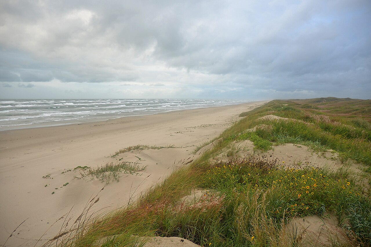
Padre Island National Seashore protects roughly 66 miles of raw Gulf Coast barrier island south of Corpus Christi. While summer brings stifling humidity and biting flies, November delivers a hard reset. Daytime highs hover in the mid-70s, the brutal heat breaks, and passing cold fronts knock down insect activity along the tide line. It is the prime window to pitch a tent right above the high-water mark without cooking in your sleeping bag. The terrain is stark, flat, and constantly shifting. On the east side lies the open Gulf of Mexico, bordered by wide sand flats, shell hash, and low dunes held together by sea oats. To the west sits the Laguna Madre, one of only six hypersaline lagoons on Earth. Between them runs a ribbon of primitive beach driving where self-sufficiency is mandatory. November also marks the arrival of winter waterfowl and migratory raptors traveling the Central Flyway, turning the salt marshes and shoreline into an active birding corridor. Solitude here comes with clear rules. Once you drop past Mile 5 on South Beach, pavement and cell reception vanish entirely. You are trading amenities for wild coastal expanse, where your camp setup is dictated by tides, salt spray, and your vehicle's tire pressure.
Navigating the South Beach Track
Driving South Beach requires respect for coastal tides and tire traction. The first five miles from the Malaquite access ramp are packed hard enough for standard two-wheel-drive vehicles, but past that marker, conditions deteriorate rapidly into deep, loose sand and shell banks. Airing down to roughly 15 to 20 PSI is non-negotiable before tackling the primitive corridor. Tides can swallow driving lines twice a day, pinning vehicles against the dune base or pushing drivers into soft, engine-stalling washouts. Recovery services charge exorbitant four-figure rates to retrieve stranded rigs from the surf zone, so bring a shovel, traction boards, and a kinetic recovery strap. Driving directly on the coastal dunes or coastal vegetation is strictly illegal and damages the fragile root structures holding the island together. Always monitor local tide tables before venturing south, and never travel alone without self-recovery gear.
Laguna Madre Versus Gulf Coast
Padre Island offers two distinct marine environments split by a spine of dunes. The Gulf side faces open surf, constant onshore chop, and long runs of shell-strewn sand where beachcombers scour the drift line for sea beans and historical flotsam. The western shoreline borders the Laguna Madre, a shallow, ultra-saline lagoon protected from ocean swells. Bird Island Basin sits on the lagoon side, renowned globally as one of the best windsurfing and kiteboarding flatwater venues in the country due to reliable autumn breezes and warm, waist-deep shallows. Anglers also work these calm waters for red drum, spotted seatrout, and black drum feeding across the flats. While the Gulf invites primitive camping and heavy surf fishing, the Laguna Madre side provides launch points for paddle craft, protected wading, and a sheltered refuge when easterly Gulf winds blow out beach operations.
Late Autumn Weather Windows
November is arguably the most forgiving month on the barrier island, but weather remains dynamic. Early autumn hurricanes give way to the first crisp Northers, continental cold fronts that barrel through South Texas with sudden velocity. A front can drop temperatures twenty degrees within an hour, violently shifting prevailing southeast sea breezes into biting northwest gales. These winds blow water out of the Laguna Madre while pushing Gulf surf higher against the beach, complicating low-tide driving routes. In between fronts, however, conditions are sublime: clear skies, daylight highs in the mid-70s, and a massive decline in the mosquito and biting sand-fly populations that plague the island through September. Campers should pack heavy-duty sand stakes, guyline tensioners, and windbreaks, because unobstructed coastal gusts will easily collapse standard dome tents staked into loose coastal substrate.
Primitive Camping and Logistics
Dispersed camping along the Gulf is completely free outside the standard park entrance fee, but it demands absolute self-reliance. You must carry all drinking water, as no freshwater sources exist down the beach, and the park recommends a minimum of one gallon per person per day. Chemical toilets are available at the entrance and Mile 5, but past that point, you need a portable toilet or pack-out waste bags; digging latrines in the sand is environmentally irresponsible and often unearths with the next storm surge. Raccoon and coyote populations roam the tide lines after dark, scavenging anything left accessible, meaning coolers and trash require heavy-duty latches or in-vehicle storage. Salt spray coats everything within hours, corroding exposed metal and fogging optics, so rinse critical mechanical gear with fresh water when you return to civilization.
Wildlife Along the Central Flyway
While the summer Kemp's ridley sea turtle releases draw thousands of spectators, late autumn belongs to the avian migrations. Padre Island sits squarely within the Central Flyway, serving as a critical refueling sanctuary for thousands of migratory shorebirds, waterfowl, and birds of prey. The sandflats and mud basins host flocks of sanderlings, piping plovers, willets, and reddish egrets foraging along the shoreline wash. Peregrine falcons follow the southward migration down the barrier spit, hunting exhausted coastal birds across the dunes. Coyote tracks crisscross the beach every dawn, and in the Laguna Madre, bottlenose dolphins routinely patrol the drop-offs tracking schools of baitfish. November provides exceptional bird photography opportunities without the crowds, provided you use long glass and give resting migratory flocks plenty of space to feed without flushing.
Environmental Hazards and Preparedness
The raw nature of Padre Island carries specific hazards that catch unprepared campers off guard. Beyond high tides and deep sand, Portuguese man-o'-war often wash ashore following stiff onshore winds; their tentacles remain venomous even when stranded on the sand, posing severe risks to bare feet and roaming dogs. Marine debris, including discarded fishing line, rusted metal drums, and sharp driftwood, washes up on South Beach constantly from Gulf shipping channels. Stinging rays frequent the shallow surf, requiring the classic stingray shuffle whenever you wade into the water. Cell phone service ends within a mile or two south of the visitor center, making satellite messengers essential for emergencies. If mechanical failure or injury occurs twenty miles down island, assistance is hours away, requiring self-sufficient first aid and realistic assessment of your remote survival skills.
How we picked
We built this ranking from trip reports, agency data, permit records, and our editors' own time on the ground. 10 places made the final cut out of a much longer working list, and each one had to clear the same set of criteria before it earned a spot.
- Quality of the terrain
- Landscape, route variety, and whether the place rewards multiple days rather than one overlook.
- Season and weather windows
- How long the reliable window is, and how badly the shoulder seasons punish a bad forecast.
- Access and permits
- Trailhead logistics, permit odds, quotas, and how much lead time a trip realistically takes.
- Solitude vs. crowding
- How far you have to walk before the place feels like wilderness instead of a queue.
- Wildlife and ecology
- What you can reasonably expect to see, and what you have to plan around.
- Risk and skill required
- Navigation, water crossings, exposure, and rescue distance — stated plainly.
Padre Island National Seashore — frequently asked questions
- Is Padre Island National Seashore worth the trip?
- We rank it #10 in US Destinations in November. Mild beach camping weather on the longest undeveloped barrier island.
- Who is Padre Island National Seashore best for?
- Best for primitive 4wd beach camping, late-autumn shorebird watching, shallow flats kayak fishing and self-sufficient overlanding trips. Standouts: miles of uncrowded, free dispersed camping right on the gulf shoreline and mild late-autumn temperatures provide relief from oppressive summer heat.
- What are the drawbacks of Padre Island National Seashore?
- Driving down island requires 4WD, sand recovery gear, and tide vigilance, Salt spray, blowing sand, and sudden cold fronts stress vehicles and camp gear and Complete lack of water, shade, and facilities along the primitive beach driving route.
- What are the key details for Padre Island National Seashore?
- Location: Kleberg and Kenedy Counties, Texas · Managing Agency: National Park Service · Protected Shoreline: Approximately 66 miles · November Weather: Highs mid-70s, lows mid-60s, moderate winds · Beach Driving: 4WD required beyond Mile 5 on South Beach
- Navigating the South Beach Track — what should I know about the Padre Island National Seashore?
- Driving South Beach requires respect for coastal tides and tire traction. The first five miles from the Malaquite access ramp are packed hard enough for standard two-wheel-drive vehicles, but past that marker, conditions deteriorate rapidly into deep, loose sand and shell banks.
- Laguna Madre Versus Gulf Coast — what should I know about the Padre Island National Seashore?
- Padre Island offers two distinct marine environments split by a spine of dunes. The Gulf side faces open surf, constant onshore chop, and long runs of shell-strewn sand where beachcombers scour the drift line for sea beans and historical flotsam.
Where on earth
Satellite imagery flying in from a world view to Padre Island National Seashore, Texas, United States. Use the + / − buttons, or click the map to zoom with your scroll wheel; drag to pan and pinch to zoom on touch.
Padre Island National Seashore, Texas, USA · 27.086, -97.384
Wildlife found around Padre Island National Seashore


Compare side by side
Put the Padre Island National Seashore against any other pick on this list — specs, price, pros, cons and reader ratings.