


Backpacking Trips · #10
Chilkoot Trail
Alaska / BC
Reader rating
Rate it and you move it. Community ratings re-rank this product inside its Top 10 list.
Expert-picked, reader-ranked. Our editors choose the products and the launch order; member star ratings move picks up or down over time.
53 km following the Klondike gold-rush route from Skagway to Bennett Lake. History and coastal rainforest.
Pros
- Unparalleled historical immersion with abundant artifacts
- Stunning and diverse landscapes from coast to interior
- Well-maintained trail with established campsites and bear caches
- Sense of accomplishment on a genuinely challenging route
- Unique international border crossing on foot
Cons
- Unpredictable and often wet weather, even in summer
- Permits and logistical planning can be complex
- Significant potential for crowds during peak season
- Can be expensive due to train return trip and international travel
Best uses
- History buffs
- Backpackers seeking a challenge
- Those who enjoy varied terrain
- Adventure travelers
- Anyone interested in the Gold Rush era
Specifications
- Distance
- 33 miles (53 km)
- Starting Point
- Dyea, Alaska
- Ending Point
- Bennett, British Columbia
- Max Elevation
- 3,500 ft (1,067 m) at Chilkoot Pass
- Typical Duration
- 3-5 days
- Permits
- Required (US NPS / Parks Canada)
Best for
History buffs, Backpackers seeking a challenge, Those who enjoy varied terrain, Adventure travelers, Anyone interested in the Gold Rush era
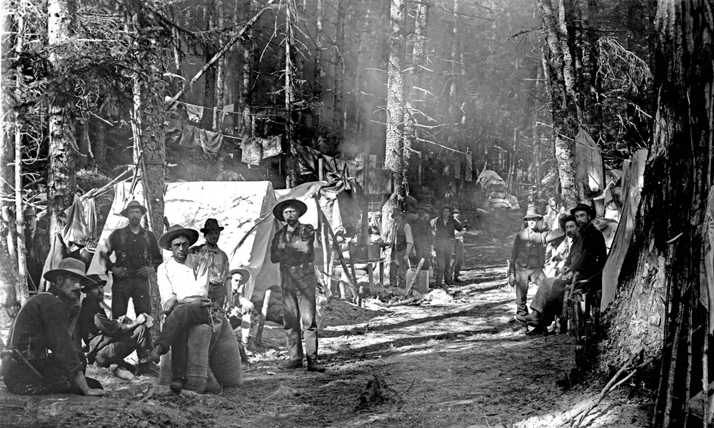
The Chilkoot Trail isn't just a hike; it's a living museum, tracing the steps of the Klondike Gold Rush stampeders from Dyea, Alaska, to Bennett, British Columbia. This 33-mile (53 km) route plunges through coastal rainforest, climbs over a rugged alpine pass, and descends into the sub-boreal forest of the Canadian interior. While the elevation gain isn't extreme, the varied terrain, from muddy bogs to boulder fields and snow patches, demands respect. What truly sets the Chilkoot apart is its unparalleled historical context. Along the entire trail, you'll find an astonishing number of artifacts – discarded boots, tins, tools, and remnants of boomtowns – left behind by those who dared to seek their fortune. It’s a physical and mental challenge that rewards with a deep connection to a pivotal moment in North American history, and a stark reminder of human determination and folly. Completing the Chilkoot Trail is more than just bagging a peak; it’s an immersive journey back in time. The trail is well-maintained and marked, yet still feels remote and wild in places. Prepare for a range of weather conditions, from persistent rain in the lower sections to sun, wind, and even snow at the higher elevations, regardless of the month. Its unique blend of demanding terrain, breathtaking scenery, and palpable history makes it a truly distinctive backpacking experience, appealing to those who appreciate a trek with a profound story to tell. Expect to spend 3 to 5 days on the trail, fully immersed in its stark beauty and enduring legacy.
Geography and Terrain
The Chilkoot Trail is a traverse from the Pacific coastal rainforest of Alaska into the sub-boreal interior of British Columbia. The initial miles are characterized by dense, often wet, temperate rainforest with moss-covered trees and a thick understory. As you ascend, the terrain transitions through subalpine forests and then opens into an exposed alpine zone around Chilkoot Pass, characterized by rocky slopes, boulder fields, and occasional snow patches even in summer. Post-pass, the landscape gradually shifts to a drier, more open forest of pine and spruce, dotted with numerous lakes, culminating at Bennett Lake. Expect significant changes underfoot, from muddy roots and boardwalks to scree, solid rock, and potentially slick surfaces.
Best Season and Weather
The ideal window for hiking the Chilkoot Trail is typically late June through early September. During this period, snow on Chilkoot Pass is usually manageable, and river crossings are generally safer. However, weather in this region is famously unpredictable. Be prepared for anything: sunshine, heavy rain, strong winds, and cold temperatures can occur on the same day or within hours. Persistent rain is common, especially on the Alaskan side. Temperatures can range from comfortable highs in the 60s°F (15-20°C) to near-freezing lows, particularly at higher elevations or in the shoulder seasons. Waterproof gear and layered clothing are non-negotiable.
Wildlife Encounters
The Chilkoot Trail is prime habitat for a variety of wildlife. Black and brown bears (grizzlies) are present throughout the corridor, particularly in the lower, denser sections. Bear spray, proper food storage in provided bear caches, and awareness are essential. Other common sightings include moose, especially in marshy areas, and various small mammals like marmots and pikas in the alpine. Birdlife is abundant, from bald eagles near the coast to diverse species in the interior forests. While exciting, wildlife encounters necessitate respect and adherence to Leave No Trace principles, maintaining safe distances and never feeding animals.
Key Routes and Attractions
The trail itself is the main attraction, a linear route without major detours. Key historical camps like Finnegan's Wake, Sheep Camp, and Canyon City offer insights into the stampeders' journey. The ascent to the 'Golden Stairs' below Chilkoot Pass is a challenging but iconic section, followed by the dramatic views from the pass itself. Post-pass, the succession of subalpine lakes (Crater Lake, Long Lake, Lindeman Lake) provides stunning scenery and additional historical remnants. The trail concludes at Bennett, British Columbia, a historic railway town, where the White Pass and Yukon Route Railway offers a scenic return journey to Skagway, completing the historical loop.
Permits and Access
Permits are mandatory for hiking the Chilkoot Trail and are managed jointly by the U.S. National Park Service (NPS) and Parks Canada. Reservations are highly recommended, especially for peak season, as daily quotas are enforced. Hikers must register and obtain their permit in Skagway, Alaska, before starting. The trail typically begins in Dyea, accessible by shuttle or taxi from Skagway. Upon completion at Bennett, BC, most hikers take the White Pass & Yukon Route train back to Skagway or Carcross. It's crucial to plan your return transport and clear Canadian customs before beginning the Canadian section of the trail.
How we chose
We built this ranking from trip reports, agency data, permit records, and our editors' own time on the ground. 10 places made the final cut out of a much longer working list, and each one had to clear the same set of criteria before it earned a spot.
- Quality of the terrain
- Landscape, route variety, and whether the place rewards multiple days rather than one overlook.
- Season and weather windows
- How long the reliable window is, and how badly the shoulder seasons punish a bad forecast.
- Access and permits
- Trailhead logistics, permit odds, quotas, and how much lead time a trip realistically takes.
- Solitude vs. crowding
- How far you have to walk before the place feels like wilderness instead of a queue.
- Wildlife and ecology
- What you can reasonably expect to see, and what you have to plan around.
- Risk and skill required
- Navigation, water crossings, exposure, and rescue distance — stated plainly.
Chilkoot Trail — frequently asked questions
- Is Chilkoot Trail worth the trip?
- We rank it #10 in Backpacking Trips. 53 km following the Klondike gold-rush route from Skagway to Bennett Lake. History and coastal rainforest.
- Who is Chilkoot Trail best for?
- Best for history buffs, backpackers seeking a challenge, those who enjoy varied terrain and adventure travelers. Standouts: unparalleled historical immersion with abundant artifacts and stunning and diverse landscapes from coast to interior.
- What are the drawbacks of Chilkoot Trail?
- Unpredictable and often wet weather, even in summer, Permits and logistical planning can be complex and Significant potential for crowds during peak season.
- What are the key details for Chilkoot Trail?
- Distance: 33 miles (53 km) · Starting Point: Dyea, Alaska · Ending Point: Bennett, British Columbia · Max Elevation: 3,500 ft (1,067 m) at Chilkoot Pass · Typical Duration: 3-5 days
- Geography and Terrain — what should I know about the Chilkoot Trail?
- The Chilkoot Trail is a traverse from the Pacific coastal rainforest of Alaska into the sub-boreal interior of British Columbia. The initial miles are characterized by dense, often wet, temperate rainforest with moss-covered trees and a thick understory.
- Best Season and Weather — what should I know about the Chilkoot Trail?
- The ideal window for hiking the Chilkoot Trail is typically late June through early September. During this period, snow on Chilkoot Pass is usually manageable, and river crossings are generally safer.
Where on earth
Satellite imagery flying in from a world view to Chilkoot Trail. Use the + / − buttons, or click the map to zoom with your scroll wheel; drag to pan and pinch to zoom on touch.
Chilkoot Trail · 59.702, -135.230
Wildlife found around Chilkoot Trail








Compare side by side
Put the Chilkoot Trail against any other pick on this list — specs, price, pros, cons and reader ratings.