


Backpacking Trips · #1
John Muir Trail
California, USA
Reader rating
Rate it and you move it. Community ratings re-rank this product inside its Top 10 list.
Expert-picked, reader-ranked. Our editors choose the products and the launch order; member star ratings move picks up or down over time.
340 km through the High Sierra. Permit-heavy, unmatched alpine scenery.
Pros
- Uninterrupted high-alpine scenery for 211 miles
- World-class wilderness experience
- Well-maintained trail infrastructure
- Opportunity for profound personal challenge and growth
- Abundant natural water sources (seasonal)
Cons
- Extremely difficult to obtain permits
- Can be crowded in peak season
- Significant elevation gain and exposure to elements
- Requires extensive planning and logistical coordination
- Potential for dangerous river crossings and unpredictable weather
Best uses
- Long-distance backpacking
- High-alpine wilderness immersion
- Physical and mental challenge
- Stargazing and photography
- Experiencing iconic Sierra vistas
Specifications
- Location
- High Sierra, California, USA
- Length
- 211 miles (340 km)
- Start
- Happy Isles, Yosemite Valley
- End
- Mount Whitney Summit
- Elevation Gain
- Approximately 47,000 ft (14,300 m)
- Permits
- Required for all overnight stays
- Best Season
- July to September
Best for
Long-distance backpacking, High-alpine wilderness immersion, Physical and mental challenge, Stargazing and photography, Experiencing iconic Sierra vistas
The John Muir Trail, or JMT, is a quintessential American long-distance hiking experience, stretching 211 miles (340 km) through the heart of California's High Sierra Nevada mountains. This isn't just a walk; it's an immersion into granite peaks, glacial valleys, and some of the most pristine alpine environments on the planet. From Yosemite Valley to Mount Whitney, hikers traverse elevations ranging from 4,000 to over 14,500 feet, often spending weeks above the tree line. The trail is almost entirely within designated wilderness, demanding self-sufficiency and respect for the fragile ecosystems it crosses. Its popularity, while a testament to its beauty, also necessitates careful planning around permits and logistics, particularly for southbound thru-hikers aiming for Mount Whitney's summit. What sets the JMT apart isn't just its continuous stretch of high-alpine splendor, but the sustained challenge it offers. Hikers regularly cross passes above 11,000 feet, navigate diverse terrain, and experience significant weather shifts within a single day. The remoteness means resupply points are strategic efforts, and emergency services are often days away. This journey isn't for the faint of heart or the unprepared. It requires meticulous planning, a solid understanding of wilderness ethics, and a robust physical and mental fortitude. But for those who undertake it, the rewards are immeasurable: unparalleled views, profound solitude, and a deep connection to one of North America's most iconic mountain ranges.
Geography and Terrain
The JMT primarily follows the Sierra Nevada crest, characterized by dramatic granite spires, U-shaped glacial valleys, and countless alpine lakes. The trail crosses numerous high passes, including Donohue, Muir, Mather, Pinchot, Taboose, and Forester Pass (the highest point on the JMT itself at 13,153 feet, not including the Mt. Whitney detour). Terrain varies from well-maintained dirt paths to rocky ascents and descents, sometimes requiring scrambling over boulders. Water is generally abundant from snowmelt and streams, though long dry stretches can occur in late season or drought years. Expect significant elevation changes daily, demanding good navigation skills and comfortable footing.
Best Season and Weather
The ideal window for hiking the JMT is typically from mid-July to mid-September. Earlier in the season, significant snowpack can make high passes treacherous and creek crossings dangerous due to powerful snowmelt. Later into September, daytime temperatures remain pleasant, but nights become much colder, and the risk of early-season snowstorms increases. Summer thunderstorms are common in the afternoons, bringing sudden rain, hail, and lightning. Hikers must be prepared for extreme temperature swings, from warm, sunny days to freezing nights, and for rapid changes in weather conditions at higher elevations.
Wildlife Encounters
The JMT traverses critical habitat for a variety of Sierra Nevada wildlife. Expect to see marmots, pikas, deer, and numerous bird species, including Clark's Nutcrackers. Black bears are prevalent throughout the entire length of the trail, necessitating strict adherence to bear canister regulations for food storage. Mountain lions are present but rarely seen. Hikers should practice Leave No Trace principles diligently, especially regarding food and waste, to minimize human-wildlife conflict and protect the integrity of the wilderness ecosystem. Keep a respectful distance from all animals.
Permits and Access
Permits are the single biggest logistical hurdle for the JMT. A wilderness permit is required for any overnight stay. For southbound thru-hikers starting in Yosemite, permits are highly competitive and allocated via a lottery system up to 168 days in advance. Northbound permits from Whitney Portal or other eastern Sierra trailheads are also difficult to secure. Access to the trailheads typically involves shuttle services or personal vehicles parked at designated long-term lots. Hikers must adhere to permit regulations, including entry and exit dates, and group size limits, to protect the wilderness experience for all.
Key Routes and Attractions
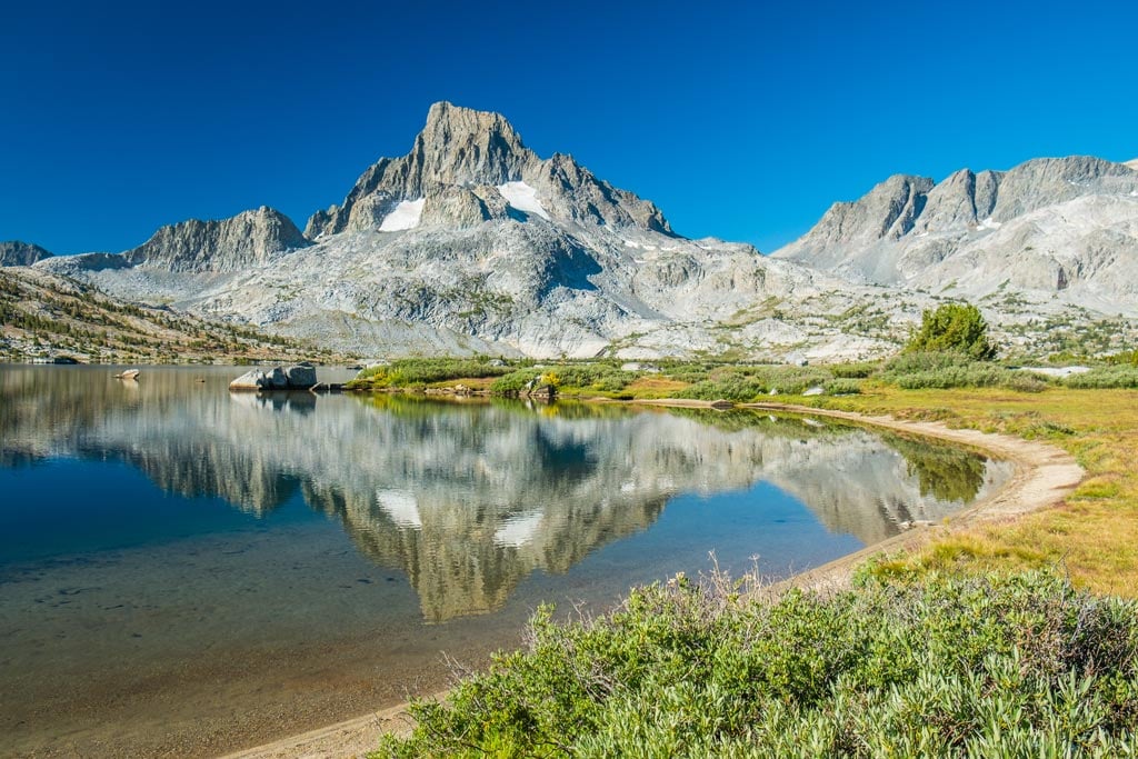
Beyond the iconic Mount Whitney summit, the JMT offers a continuous parade of stunning natural features. Notable attractions include Tuolumne Meadows in Yosemite, the scenic expanse of Little Yosemite Valley, the dramatic climb over Donohue Pass into Ansel Adams Wilderness, the evolution basin, and the pristine wilderness of Kings Canyon and Sequoia National Parks. Each day presents new vistas of jagged peaks, sapphire lakes like Rae Lakes, and cascading waterfalls. The trail itself is the primary attraction, offering a sustained journey through some of the most breathtaking high-alpine landscapes in the United States.
Trade-offs and Hazards
The JMT's immense popularity means solitude can be elusive, especially at major trailheads and popular campsites. Crowds, while manageable, are a reality. Significant hazards include acute mountain sickness (AMS) due to sustained high elevation, dangerous creek crossings during high snowmelt years, sudden and severe weather shifts (lightning, hail, snow), and the ever-present challenge of bear encounters. The remoteness means help is often days away, requiring hikers to be self-reliant, proficient in navigation, and prepared for emergencies. Physical demanding and mentally taxing, it's not a beginner's hike.
How we chose
We built this ranking from trip reports, agency data, permit records, and our editors' own time on the ground. 10 places made the final cut out of a much longer working list, and each one had to clear the same set of criteria before it earned a spot.
- Quality of the terrain
- Landscape, route variety, and whether the place rewards multiple days rather than one overlook.
- Season and weather windows
- How long the reliable window is, and how badly the shoulder seasons punish a bad forecast.
- Access and permits
- Trailhead logistics, permit odds, quotas, and how much lead time a trip realistically takes.
- Solitude vs. crowding
- How far you have to walk before the place feels like wilderness instead of a queue.
- Wildlife and ecology
- What you can reasonably expect to see, and what you have to plan around.
- Risk and skill required
- Navigation, water crossings, exposure, and rescue distance — stated plainly.
John Muir Trail — frequently asked questions
- Is John Muir Trail worth the trip?
- We rank it #1 in Backpacking Trips. 340 km through the High Sierra. Permit-heavy, unmatched alpine scenery.
- Who is John Muir Trail best for?
- Best for long-distance backpacking, high-alpine wilderness immersion, physical and mental challenge and stargazing and photography. Standouts: uninterrupted high-alpine scenery for 211 miles and world-class wilderness experience.
- What are the drawbacks of John Muir Trail?
- Extremely difficult to obtain permits, Can be crowded in peak season and Significant elevation gain and exposure to elements.
- What are the key details for John Muir Trail?
- Location: High Sierra, California, USA · Length: 211 miles (340 km) · Start: Happy Isles, Yosemite Valley · End: Mount Whitney Summit · Elevation Gain: Approximately 47,000 ft (14,300 m)
- Geography and Terrain — what should I know about the John Muir Trail?
- The JMT primarily follows the Sierra Nevada crest, characterized by dramatic granite spires, U-shaped glacial valleys, and countless alpine lakes. The trail crosses numerous high passes, including Donohue, Muir, Mather, Pinchot, Taboose, and Forester Pass (the highest point on the JMT itself at 13,153 feet, not…
- Best Season and Weather — what should I know about the John Muir Trail?
- The ideal window for hiking the JMT is typically from mid-July to mid-September. Earlier in the season, significant snowpack can make high passes treacherous and creek crossings dangerous due to powerful snowmelt.
Where on earth
Satellite imagery flying in from a world view to John Muir Trail, California, United States. Use the + / − buttons, or click the map to zoom with your scroll wheel; drag to pan and pinch to zoom on touch.
John Muir Trail, California, USA · 37.235, -118.871
Wildlife found around John Muir Trail








Compare side by side
Put the John Muir Trail against any other pick on this list — specs, price, pros, cons and reader ratings.