


Reader rating
Rate it and you move it. Community ratings re-rank this product inside its Top 10 list.
Expert-picked, reader-ranked. Our editors choose the products and the launch order; member star ratings move picks up or down over time.
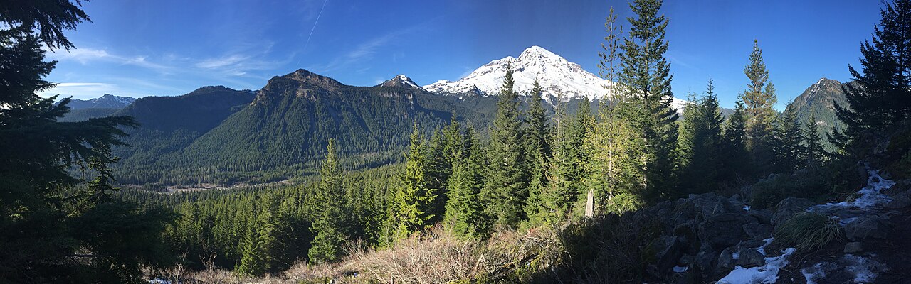
Lower trails clear; glaciers gleam on clear days.
Pros
- Peak waterfall flow fed by massive early-season glacial and snow melt
- Lower valley trails and old-growth groves are fully snow-free and quiet
- Prime mountaineering window with solid early-season snow bridges on glaciers
- Significantly smaller trail crowds than during the peak July and August rush
Cons
- Subalpine trails including Skyline remain buried under deep, slushy snowpack
- Sunrise road and eastern alpine visitor centers are generally closed until July
- Timed-entry reservation system requires strict advance planning for entry
Best uses
- Glacial mountaineering ascents
- Low-elevation old-growth day hikes
- High-volume waterfall photography
- Subalpine snowshoe day trips
Specifications
- Elevation Range
- 1,880 feet to 14,411 feet at the summit
- Road Status
- Paradise corridor open; Sunrise typically closed until July
- Primary Hazard
- Snow bridges, rapid snowmelt, and sudden whiteouts
- Timed Entry
- Required for Nisqually and Sunrise corridors in daytime
- Camping Access
- Cougar Rock and Ohanapecosh open for reservations
- Wilderness Permits
- Mandatory year-round for all overnight backcountry stays
Best for
Glacial mountaineering ascents, Low-elevation old-growth day hikes, High-volume waterfall photography, Subalpine snowshoe day trips
Mount Rainier in June is defined by dramatic seasonal transition. While high-summer visitors wait for August wildflower blooms, early summer delivers something far more elemental: an active 14,411-foot volcano shaking off winter. The lower valleys along the Nisqually and Ohanapecosh rivers are fully thawed, offering moss-carpeted old-growth hemlocks and roaring snowmelt waterfalls. Higher up, iconic hubs like Paradise still carry deep snowfields, glowing brilliantly under early summer high-pressure systems while Sunrise remains shuttered under drifts. Visiting during this window requires managing expectations and packing for multiple seasons in a single morning. June is not the month for a casual lap on the Wonderland Trail, as high-elevation passes remain buried under technical snow. Instead, it is prime time for backcountry snowshoeing, uncrowded lower-elevation dirt hikes, and technical glacier mountaineering before deep crevasse fields break apart under late-summer heat. Crowds are lighter than during peak midsummer, but logistical planning remains serious business. The park requires timed-entry vehicle reservations for high-traffic corridors during peak daytime hours, and Cascade weather can flip from brilliant sunshine to freezing rain without warning. Black bears forage on newly cleared avalanche shoots, and river crossings run dangerously high with spring melt.
Early Summer Terrain Realities
June on the mountain is split between two distinct ecosystems. Below 3,500 feet, low-elevation rainforests like the Carbon River and Ohanapecosh valleys are clear, damp, and running with snowmelt. Above 5,000 feet, including the subalpine meadows around Paradise, an expansive snowpack remains several feet deep well past solstice. Hikers hoping for dry dirt trails will find miles of continuous snow instead. This snow is dense in the early morning and transforms into slush by midday, creating severe postholing hazards along unmaintained paths. Off-trail route finding requires navigating around melting snow bridges, collapsing cornices, and emerging meltwater streams hidden under hollow drifts. Carrying waterproof footwear, gaiters, and traction devices such as microspikes is non-negotiable, even for marked subalpine routes like the Skyline Trail loop.
The High Route Window
For technical climbers tackling the volcano via the Disappointment Cleaver or Emmons Glacier routes, June represents the sweet spot of the climbing season. Crevasses are still largely bridged by winter snowpack, lowering the hazard profile compared to the shattered, dry-ice labyrinths of late August. However, this early window comes with serious cold snaps and high-velocity summit winds. Route conditions shift daily based on freeze-thaw cycles; firm morning cramponing can degenerate into calf-deep slush on descent. Guide services ramp up their operations now, meaning high-camp hubs like Camp Muir and Camp Schurman see steady foot traffic. Independent climbers must carry avalanche gear, crevasse rescue setups, and proven whiteout navigation tools, as sudden lenticular clouds can plunge the upper mountain into zero-visibility storms within half an hour.
Waterfalls and Valley Trails
The real reward of a June trip lies in water volume. Glacial melt combined with lingering spring rains feeds cascading torrents that dwarf their late-summer trickles. The Nisqually entrance corridor provides reliable access to waterfalls running at maximum discharge. Christine Falls and Narada Falls rumble with tremendous force, kicking up heavy spray that chills the surrounding air. For dirt hiking, Rampart Ridge offers steep climbs out of Longmire through towering Douglas firs and western redcedars, yielding early views of Rainier's south face without requiring technical snow travel until the highest ridge sections. The Silver Falls loop near Ohanapecosh delivers another accessible route, tracing the surging river through old-growth groves. Footbridges across river channels may still be undergoing seasonal repairs, so checking ranger updates at visitor centers is mandatory before heading out.
Permits and Reservation Protocols
The National Park Service implements a timed-entry reservation system to mitigate gridlock along major access roads during summer. In June, visitors entering through the Nisqually or Stevens Canyon corridors between 7:00 a.m. and 3:00 p.m. must hold an advance timed-entry permit alongside their park pass. Those entering before 7:00 a.m. or after 3:00 p.m. can bypass the reservation checkpoint, a tactic favored by early-rising climbers and trail runners. Backcountry overnight camping requires a wilderness permit issued through Recreation.gov, with a fraction held for in-person walk-ups at ranger stations. June walk-up permits for low-elevation camps are relatively accessible, but high-elevation camps like Muir fill weeks ahead. Be prepared for ranger checks along trails, and ensure food storage protocols are strictly followed to deter black bears active in thawed corridors.
Wildlife and Spring Hazards
Wildlife activity spikes across the lower and middle elevations as forage returns. Black bears emerge from winter dens and regularly feed along avalanche chutes where fresh sedges, roots, and glacier lilies sprout first. Keep a strict 100-yard buffer and never leave packs unattended, as habituated camp scavengers like gray jays and chipmunks target unguarded gear. Spring thaw introduces unique hazards beyond wildlife. Rapid runoff swells minor creeks into unfordable torrents, easily sweeping away hikers attempting unbridged backcountry crossings. Rockfall and wet-loose avalanches become common on steep, solar-facing slopes during unseasonably warm afternoons. Glare off the high snowpack is intense; high-altitude UV radiation causes rapid snow blindness and second-degree sunburn without category 3 or 4 glacier glasses and zinc sunscreen applied repeatedly throughout the day.
How we picked
We built this ranking from trip reports, agency data, permit records, and our editors' own time on the ground. 10 places made the final cut out of a much longer working list, and each one had to clear the same set of criteria before it earned a spot.
- Quality of the terrain
- Landscape, route variety, and whether the place rewards multiple days rather than one overlook.
- Season and weather windows
- How long the reliable window is, and how badly the shoulder seasons punish a bad forecast.
- Access and permits
- Trailhead logistics, permit odds, quotas, and how much lead time a trip realistically takes.
- Solitude vs. crowding
- How far you have to walk before the place feels like wilderness instead of a queue.
- Wildlife and ecology
- What you can reasonably expect to see, and what you have to plan around.
- Risk and skill required
- Navigation, water crossings, exposure, and rescue distance — stated plainly.
Mount Rainier National Park — frequently asked questions
- Is Mount Rainier National Park worth the trip?
- We rank it #9 in US Destinations in June. Lower trails clear; glaciers gleam on clear days.
- Who is Mount Rainier National Park best for?
- Best for glacial mountaineering ascents, low-elevation old-growth day hikes, high-volume waterfall photography and subalpine snowshoe day trips. Standouts: peak waterfall flow fed by massive early-season glacial and snow melt and lower valley trails and old-growth groves are fully snow-free and quiet.
- What are the drawbacks of Mount Rainier National Park?
- Subalpine trails including Skyline remain buried under deep, slushy snowpack, Sunrise road and eastern alpine visitor centers are generally closed until July and Timed-entry reservation system requires strict advance planning for entry.
- What are the key details for Mount Rainier National Park?
- Elevation Range: 1,880 feet to 14,411 feet at the summit · Road Status: Paradise corridor open; Sunrise typically closed until July · Primary Hazard: Snow bridges, rapid snowmelt, and sudden whiteouts · Timed Entry: Required for Nisqually and Sunrise corridors in daytime · Camping Access: Cougar Rock and Ohanapecosh open for reservations
- Early Summer Terrain Realities — what should I know about the Mount Rainier National Park?
- June on the mountain is split between two distinct ecosystems. Below 3,500 feet, low-elevation rainforests like the Carbon River and Ohanapecosh valleys are clear, damp, and running with snowmelt.
- The High Route Window — what should I know about the Mount Rainier National Park?
- For technical climbers tackling the volcano via the Disappointment Cleaver or Emmons Glacier routes, June represents the sweet spot of the climbing season. Crevasses are still largely bridged by winter snowpack, lowering the hazard profile compared to the shattered, dry-ice labyrinths of late August.
Where on earth
Satellite imagery flying in from a world view to Mount Rainier National Park, Washington, United States. Use the + / − buttons, or click the map to zoom with your scroll wheel; drag to pan and pinch to zoom on touch.
Mount Rainier National Park, Washington, USA · 46.867, -121.700
Wildlife found around Mount Rainier National Park








Compare side by side
Put the Mount Rainier National Park against any other pick on this list — specs, price, pros, cons and reader ratings.