


Reader rating
Rate it and you move it. Community ratings re-rank this product inside its Top 10 list.
Expert-picked, reader-ranked. Our editors choose the products and the launch order; member star ratings move picks up or down over time.
Porcupine Mountains and Pictured Rocks in full color.
Pros
- World-class hardwood fall foliage contrasting against massive freshwater seascapes
- Summer humidity, mosquitoes, and biting blackflies are completely gone
- Backcountry trails and iconic overlooks see a fraction of summer visitor traffic
- Vast tracts of interconnected national forest, state land, and wilderness areas
Cons
- Superior weather shifts violently, bringing gales, freezing rain, and early blizzards
- Many state park facilities, water systems, and local services shutter by mid-month
- Widespread cell phone dead zones require self-sufficient navigation and communication
Best uses
- Fall foliage photography
- Cold-weather wilderness backpacking
- Lake Superior coastal hiking
- Remote forest gravel driving
Specifications
- Primary Gateways
- Marquette, Munising, Houghton, St. Ignace
- Peak Foliage
- Early to mid-October
- Key Waterbody
- Lake Superior
- Trail Systems
- North Country Trail, Porcupine Mountains network
- Access Passes
- Michigan Recreation Passport, NPS Park Pass
- Primary Hazards
- Sudden coastal gales, hypothermia, remote routes
Best for
Fall foliage photography, Cold-weather wilderness backpacking, Lake Superior coastal hiking, Remote forest gravel driving
Michigan's Upper Peninsula covers nearly a third of the state's landmass yet holds barely three percent of its population. In October, this dense belt of boreal woods, northern hardwoods, and ancient bedrock delivers one of the most intense autumn color displays on the continent. The canopy transitions into deep ambers, fiery scarlets, and vivid ochres, flanked on three sides by the frigid waters of Lake Superior, Lake Michigan, and Lake Huron. Traveling the northern rim late in the season requires a pragmatic approach to conditions. October strips away the brutal summer humidity and biting blackfly swarms, leaving quiet trails, crisp air, and uncrowded overlooks. However, Lake Superior dictates the terms. Fronts roll off the open water with little warning, swapping sunny afternoon hikes for driving sleet or early lake-effect flurries within a matter of hours. Those prepared for sudden shifts in temperature will find an austere, untamed corridor at its visual peak. From the rugged cliffs above Lake of the Clouds to the sandstone ramparts of Pictured Rocks, the region offers backcountry solitude and coastal hiking that rival any wilderness area in the lower forty-eight.
Porcupine Mountains Escarpment
The Porcupine Mountains Wilderness State Park encompasses 60,000 acres of old-growth northern hardwoods and hemlock-hardwood forest along Lake Superior's western edge. The signature vantage sits high on the Escarpment Trail, where the ground falls away hundreds of feet to reveal the Lake of the Clouds framed by blazing sugar maples and basswoods. Foot travel here involves uneven bedrock, slick roots, and sustained elevation changes over rocky ridges. October hikers on the Big Carp and Little Carp River loops will encounter raw wilderness conditions, rushing brown-water rivers fed by autumn rains, and cold timbered valleys where frost lingers until midday. Backcountry sites along the ridges stay exposed to lake winds, making sturdy shelter pitching essential. Bridge crossings are sparse on deeper trails, and water levels can surge overnight after heavy rainfall.
Pictured Rocks Coastal Trail
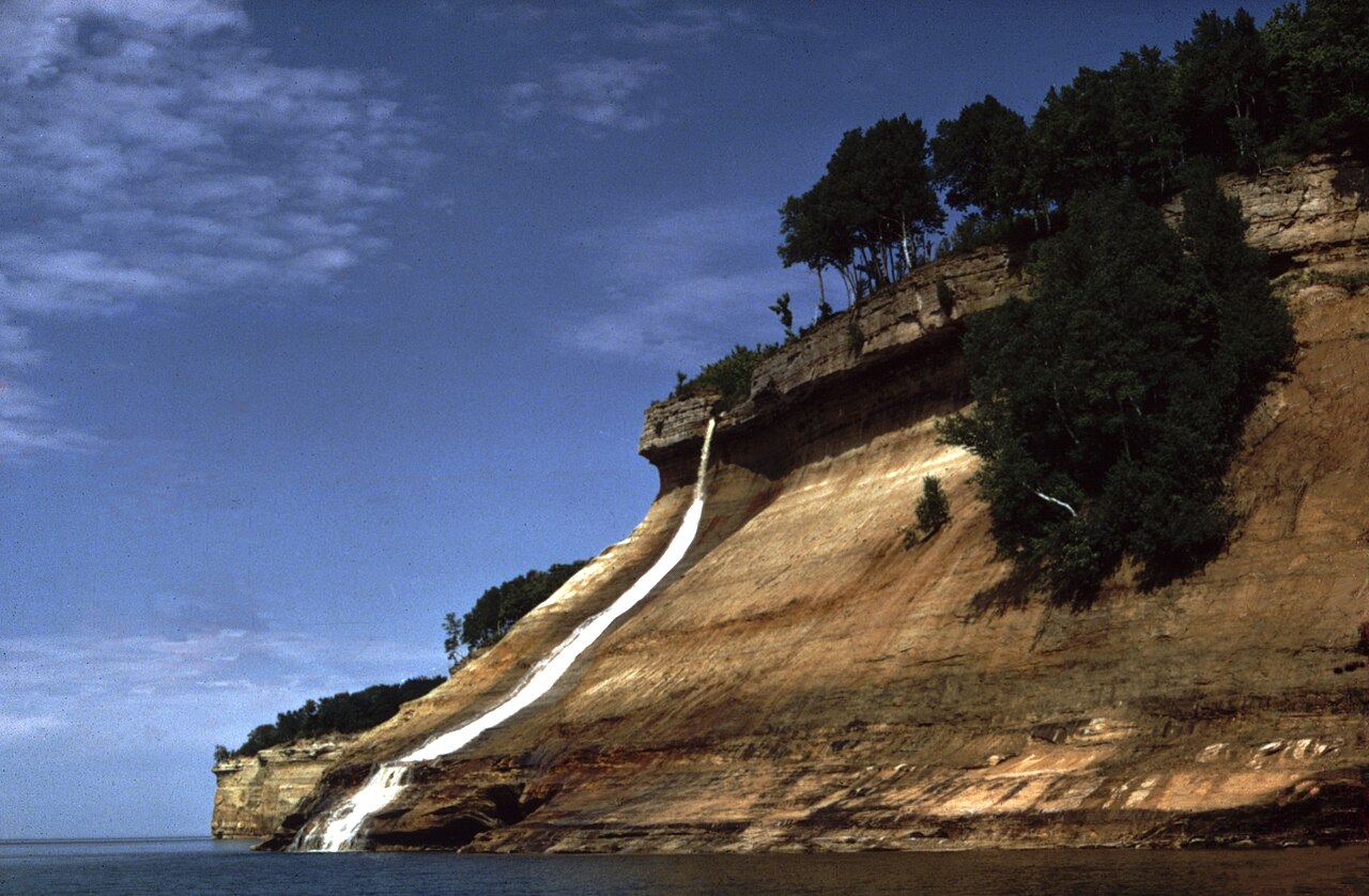
Stretching forty-two miles between Munising and Grand Marais, Pictured Rocks National Lakeshore features 200-foot multi-colored sandstone cliffs towering directly over the open lake. Walking the Chapel Loop or the North Country National Scenic Trail section in October puts you alongside birch and maple groves contrasted against turquoise, slate-gray water. Summer tour boats wind down operations early in the month, and kayaking becomes treacherous as Superior generates formidable autumn swells and hypothermic water temperatures. On foot, however, the cliff paths offer uninhibited solitude. High winds along Grand Portal Point and Miners Beach will test your layering system, and maritime squalls can blow in thick fog that eliminates cliffline visibility. Water sources along the trail require filtration, and exposed roots become slick as grease after cold coastal rain showers.
Weather Windows and Lake Effects
October in the UP is defined by relentless volatility driven by the largest freshwater lake on earth. Early October days can bring mild 60-degree sunshine, but temperatures drop precipitously the moment the sun dips behind the ridge, frequently falling below freezing inland. By the second and third weeks of the month, the jet stream regularly drives low-pressure systems across the region, producing the infamous gales of November several weeks ahead of schedule. Rain often turns to horizontal graupel or wet snow with little forewarning, soaking poorly prepared hikers. Cotton gear has no place on these trails; full waterproof-breathable outerwear, wool midlayers, and reliable traction for muddy descents are basic requirements. If car camping or backpacking, assume your tent will face sustained gusts exceeding thirty miles per hour along the coast.
Wildlife and Active Hunting Seasons
The massive expanse of public land makes the peninsula a stronghold for northern wildlife, but October requires heightened spatial awareness. Black bears are in peak hyperphagia, roaming widely to forage on acorns and beechnuts before winter denning; proper food hangs or certified bear canisters are mandatory in the backcountry. Moose are occasionally spotted browsing bogs in Marquette and Baraga counties, often active during the autumn rut. Whitetail deer are abundant, which coincides with Michigan's archery deer hunting season running throughout October, alongside grouse and woodcock seasons. While hunting is restricted in developed state park hubs, much of the surrounding Ottawa and Hiawatha National Forests are actively hunted. Anyone heading into the timber should wear blaze orange or high-visibility outerwear, keep trail dogs leashed and vest-clad, and remain alert around logging roads.
Logistics and Seasonal Shutdowns
Covering distances across the peninsula demands careful planning. State routes like M-28 and US-2 stretch across vast, uninhabited bogs and forests where cell service drops out for dozens of miles at a stretch, and gas stations can be spaced fifty miles apart. By mid-October, the tourist infrastructure begins shutting down. Municipal campgrounds shut off their municipal water lines to prevent frozen pipes, state park modern bathhouses shutter, and remote roadside services reduce their hours or close entirely until snowmobile season. Carry paper topo maps, an offline satellite communicator, and a vehicle emergency kit stocked with winter-weight sleeping bags, water, and recovery traction boards. Preparing for total self-reliance allows you to operate comfortably without relying on local hardware stores or late-night convenience stops that simply do not exist out here.
How we picked
We built this ranking from trip reports, agency data, permit records, and our editors' own time on the ground. 10 places made the final cut out of a much longer working list, and each one had to clear the same set of criteria before it earned a spot.
- Quality of the terrain
- Landscape, route variety, and whether the place rewards multiple days rather than one overlook.
- Season and weather windows
- How long the reliable window is, and how badly the shoulder seasons punish a bad forecast.
- Access and permits
- Trailhead logistics, permit odds, quotas, and how much lead time a trip realistically takes.
- Solitude vs. crowding
- How far you have to walk before the place feels like wilderness instead of a queue.
- Wildlife and ecology
- What you can reasonably expect to see, and what you have to plan around.
- Risk and skill required
- Navigation, water crossings, exposure, and rescue distance — stated plainly.
Upper Peninsula — frequently asked questions
- Is Upper Peninsula worth the trip?
- We rank it #6 in US Destinations in October. Porcupine Mountains and Pictured Rocks in full color.
- Who is Upper Peninsula best for?
- Best for fall foliage photography, cold-weather wilderness backpacking, lake superior coastal hiking and remote forest gravel driving. Standouts: world-class hardwood fall foliage contrasting against massive freshwater seascapes and summer humidity, mosquitoes, and biting blackflies are completely gone.
- What are the drawbacks of Upper Peninsula?
- Superior weather shifts violently, bringing gales, freezing rain, and early blizzards, Many state park facilities, water systems, and local services shutter by mid-month and Widespread cell phone dead zones require self-sufficient navigation and communication.
- What are the key details for Upper Peninsula?
- Primary Gateways: Marquette, Munising, Houghton, St. Ignace · Peak Foliage: Early to mid-October · Key Waterbody: Lake Superior · Trail Systems: North Country Trail, Porcupine Mountains network · Access Passes: Michigan Recreation Passport, NPS Park Pass
- Porcupine Mountains Escarpment — what should I know about the Upper Peninsula?
- The Porcupine Mountains Wilderness State Park encompasses 60,000 acres of old-growth northern hardwoods and hemlock-hardwood forest along Lake Superior's western edge. The signature vantage sits high on the Escarpment Trail, where the ground falls away hundreds of feet to reveal the Lake of the Clouds framed by…
- Pictured Rocks Coastal Trail — what should I know about the Upper Peninsula?
- Stretching forty-two miles between Munising and Grand Marais, Pictured Rocks National Lakeshore features 200-foot multi-colored sandstone cliffs towering directly over the open lake. Walking the Chapel Loop or the North Country National Scenic Trail section in October puts you alongside birch and maple groves…
Where on earth
Satellite imagery flying in from a world view to Upper Peninsula, Michigan, United States. Use the + / − buttons, or click the map to zoom with your scroll wheel; drag to pan and pinch to zoom on touch.
Upper Peninsula of Michigan, MI, USA · 46.537, -87.395
Wildlife found around Upper Peninsula






Compare side by side
Put the Upper Peninsula against any other pick on this list — specs, price, pros, cons and reader ratings.