


Where on earth
Satellite imagery flying in from a world view to Fish River Canyon Hike, Namibia. Use the + / − buttons, or click the map to zoom with your scroll wheel; drag to pan and pinch to zoom on touch.
- Region
- Namibia
- Biome
- Desert canyon (200–1,000 m)
- Best season
- May – September
- Difficulty
- moderate
- Backpacking
- Hiking
- Winter Camping
- Skiing
- Desert Hiking
- Canyoneering
Key takeaways
- Biome: Desert canyon (200–1,000 m)
- Best season: May – September
- Difficulty: moderate
- Top activity: backpacking
Photos of Fish River Canyon Hike
Topic summary
An 85-km 5-day hike through Africa's largest canyon — Ai-Ais to the north.
Key takeaways
- Difficulty: moderate
- Best season: May – September
Intended uses
backpacking
Climate suitability
Desert canyon (200–1,000 m)
Tools for a trip here
Picked for how, when and where you're going. Free, no signup.
- Sleep System Temp CalculatorCold nights: check your bag and pad add up to a safe sleep.
- Base Weight CalculatorEvery ounce is carried — total your kit and find your base weight.
- Pack Volume SizerSize the pack for your trip length and season.
- Water Purification MatrixTreat water from streams and lakes on trail.
- Layering CalculatorCold-season miles: layer for climbs and camp.
Plan with verified data
Fish River Canyon Hike trip tools
How to get there
Fish River Canyon is in southern Namibia. Public viewpoints are near Hobas campsite, which lies 70 kilometres north of the hot springs resort of ǀAi-ǀAis at the canyon’s lower end.
- Hobas
A campsite near the canyon’s public viewpoints. Use it as a location for planning a viewpoint visit; confirm canyon hiking access separately.
- ǀAi-ǀAis
A hot springs resort at the lower end of Fish River Canyon. Confirm any proposed hiking entry or exit arrangements before treating it as a trail access point.
Sources: Wikipedia · Wikivoyage. Confirm road and trailhead conditions with the managing agency before you leave.
Popular pursuits at Fish River Canyon Hike
- Backpacking
Multi-day travel with everything on your back — see the packing blocks below.
- Hiking
Day miles on marked trail, with route notes and trail links below.
- Winter Camping
Cold-season travel and camp craft; layering matters more than mileage.
- Skiing
Ski-touring access when the road closes for the season.
- Desert Hiking
Water carries and heat management drive the plan.
- Canyoneering
Narrows, downclimbs, and flash-flood timing.
Maps, GPS & compass for this trip
Carry a waterproof paper map and a compass you can steer by, and treat the GPS as the backup — not the other way round. Buying links go to Amazon; Wild10 earns a commission at no cost to you.
Waterproof topo maps
- Waterproof topographic map — Fish River Canyon HikeAmazon search for waterproof, tear-resistant topo maps covering this area.
- National Geographic Trails IllustratedThe waterproof Trails Illustrated series — check for a sheet covering this area.
- Waterproof map case & compass lanyardKeep a paper map readable in rain, spray and a swamped boat.
Fishing at Fish River Canyon Hike
Planning to fish Fish River Canyon Hike, Namibia? Fishing licences, open seasons and catch limits in Namibia are set by the local wildlife authority and change every year — check the official source before you cast a line.
Do I need a fishing licence at Fish River Canyon Hike?
- A Namibia fishing licence is normally required for anyone over the local youth age.
- Read the current Namibia fishing regulations for special waters, barbless-hook or catch-and-release rules.
- Clean, drain and dry boats and gear between waters to stop invasive species.
We don't have a verified licensing link on file for Namibia yet — contact the park or land manager listed on this page for current hunting and fishing rules.
Hunting near Fish River Canyon Hike
Thinking about hunting Fish River Canyon Hike, Namibia? Hunting seasons, tags and draws in Namibia are set by the wildlife authority each year. Confirm the rules for your species and unit before you go.
Is hunting allowed at Fish River Canyon Hike?
- Confirm the land around Fish River Canyon Hike is open to hunting and which management unit it falls in.
What do I need to hunt in Namibia?
- A Namibia hunting licence — most jurisdictions also require hunter education certification.
- Species tags or draw results for big game such as deer, elk, moose or bear where they occur.
- Knowledge of firearm and bow transport rules, which differ by land type and border crossing.
We don't have a verified licensing link on file for Namibia yet — contact the park or land manager listed on this page for current hunting and fishing rules.
A deep canyon in southern Namibia
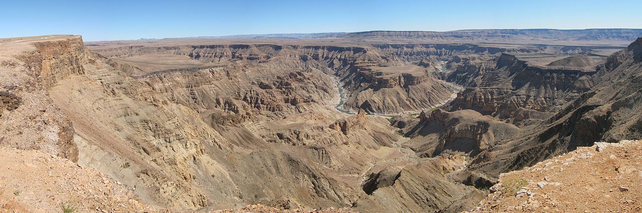
Fish River Canyon cuts through the dry plateau of southern Namibia. It is Africa’s largest canyon: the ravine extends about 160 kilometres, reaches up to 27 kilometres wide, and drops almost 550 metres in places. Those figures describe the canyon itself, not the length or elevation change of a hiking route. The surrounding ground is stony, with sparse cover from drought-resistant plants. For walkers, that landscape calls for careful preparation for sun exposure, heat and rough footing rather than expectations of shade or easy travel. The canyon’s scale is central to planning a visit: seeing it from a public viewpoint and travelling within the ravine are different undertakings, and a viewpoint visit should not be treated as confirmation of hiking access.
The river and conditions underfoot
The Fish River is Namibia’s longest interior river, but it does not flow continuously through the year. It usually floods in late summer; outside that period, it becomes a chain of long, narrow pools. That changing character matters when considering a canyon hike. Visible pools should not be treated as a guarantee of dependable drinking water, and a dry-looking river corridor should not be assumed free of flood risk. Check current weather and river conditions before setting out, and plan water supplies and treatment conservatively. Footwear suited to stony terrain, sun protection and a realistic assessment of heat exposure belong in the preparation. Seasonal river behaviour alone does not establish a safe hiking season or show whether a particular route is open.
Viewpoints, the lower canyon and hiking access
Hobas and ǀAi-ǀAis are the named places to distinguish when planning a visit. Public viewpoints lie near Hobas, a campsite 70 kilometres north of ǀAi-ǀAis. At the canyon’s lower end, ǀAi-ǀAis is a hot springs resort. These places provide different ways to approach the destination, but they should not automatically be treated as confirmed trailheads or the endpoints of a defined walking itinerary. The public-viewpoint part of the canyon lies within ǀAi-ǀAis/Richtersveld Transfrontier Park, while the remainder is privately owned. That split makes access checks important before leaving established visitor areas. Confirm hiking permissions, current access arrangements and route details with the managing agency before committing to a canyon descent. Plan transport only after the intended entry and exit arrangements have been verified.
Route options
- Public viewpoints near Hobas
Choose a viewpoint visit to see the canyon without assuming access to the ravine below. This is a sightseeing option rather than a defined canyon hiking itinerary.
- Lower-canyon visit at ǀAi-ǀAis
Visit the hot springs resort at the canyon’s lower end. Any walking itinerary beyond the resort requires separate confirmation of the route and access arrangements.
Sample itineraries
- Hobas canyon viewpoints · 1 day
Plan a day around the public viewpoints near Hobas. Focus on the canyon landscape and its dry, stony plateau. This is a viewpoint visit, not a canyon-floor hiking itinerary.
- Hobas and ǀAi-ǀAis · 2 days
Spend one day at the public viewpoints near Hobas and another visiting the hot springs resort of ǀAi-ǀAis at the canyon’s lower end. Confirm local access and accommodation separately; this plan does not describe a walking route between them.
Seasonal conditions
Spring
Southern Hemisphere spring
Outside the usual late-summer flooding period, the intermittent Fish River generally forms long, narrow pools. Do not assume continuous flowing water. Confirm current river conditions and hiking access before planning a canyon descent.
Summer
Southern Hemisphere summer, especially late summer
The Fish River usually floods in late summer. Flooding can change canyon travel conditions substantially. Check current river conditions with the managing agency rather than treating a dry riverbed as a dependable walking corridor.
Fall
Southern Hemisphere fall
Check river conditions after the usual late-summer flood period. The river flows intermittently and otherwise becomes a chain of pools; neither water availability nor safe passage should be assumed.
Winter
Southern Hemisphere winter
The canyon sits within a dry, stony landscape with sparse drought-resistant vegetation. Plan for exposure and uncertain water availability. Confirm current weather and authorized hiking access rather than assuming winter guarantees suitable conditions.
| Season | Window | Conditions |
|---|---|---|
| Spring | Southern Hemisphere spring | Outside the usual late-summer flooding period, the intermittent Fish River generally forms long, narrow pools. Do not assume continuous flowing water. Confirm current river conditions and hiking access before planning a canyon descent. |
| Summer | Southern Hemisphere summer, especially late summer | The Fish River usually floods in late summer. Flooding can change canyon travel conditions substantially. Check current river conditions with the managing agency rather than treating a dry riverbed as a dependable walking corridor. |
| Fall | Southern Hemisphere fall | Check river conditions after the usual late-summer flood period. The river flows intermittently and otherwise becomes a chain of pools; neither water availability nor safe passage should be assumed. |
| Winter | Southern Hemisphere winter | The canyon sits within a dry, stony landscape with sparse drought-resistant vegetation. Plan for exposure and uncertain water availability. Confirm current weather and authorized hiking access rather than assuming winter guarantees suitable conditions. |
Permits, fees & closures
Confirm hiking permits, access requirements and booking arrangements with the managing agency for ǀAi-ǀAis/Richtersveld Transfrontier Park.
Confirm current permits, fees, and closures with the managing agency before you go.
Hazards & regulations
- Late-summer flooding: the intermittent Fish River can flood, making current river information essential before canyon travel.
- Uncertain water supply: long, narrow pools replace continuous flow for much of the year. Do not assume water is available or safe to drink.
- Uneven footing: the dry, stony landscape calls for stable footwear and careful movement.
- Exposure: sparse vegetation provides limited shelter from the sun. Carry sun protection and sufficient drinking water.
- Steep terrain: the canyon reaches almost 550 metres deep in places. Keep clear of exposed edges and do not improvise descents from viewpoints.
What to pack for Fish River Canyon Hike
- Drinking water appropriate to the outing
- Water treatment for any planned use of natural pools
- Sun hat
- Sunscreen
- Protective clothing
- Sturdy footwear for stony ground
- First-aid kit
- Blister supplies
- Weather-appropriate layers
- Current access guidance from the managing agency
- Navigation materials appropriate to the authorized route
- A communication and emergency plan
Fish River Canyon Hike FAQ
- Where is Fish River Canyon?
- It is in southern Namibia. The public-viewpoint area near Hobas belongs to ǀAi-ǀAis/Richtersveld Transfrontier Park; the remainder of the canyon is privately owned.
- Where can the canyon be viewed without planning a canyon-floor hike?
- Public viewpoints are near Hobas, a campsite 70 kilometres north of ǀAi-ǀAis. Confirm local access before travelling.
- How large is the canyon?
- The ravine is about 160 kilometres long, up to 27 kilometres wide and almost 550 metres deep in places. These are canyon dimensions, not hiking-route distances.
- Does the Fish River flow all year?
- No. It flows intermittently, usually flooding in late summer. For the rest of the year, it generally becomes a chain of long, narrow pools.
- Can these itineraries be used as a canyon hiking plan?
- No. They cover viewpoint and resort visits only. Obtain an authorized route, current access requirements and river-condition guidance from the managing agency before arranging a canyon-floor hike.
- What is at the lower end of the canyon?
- The hot springs resort of ǀAi-ǀAis is at the lower end of Fish River Canyon. Confirm resort arrangements separately from any hiking plans.