


Where on earth
Satellite imagery flying in from a world view to Matterhorn, Worldwide. Use the + / − buttons, or click the map to zoom with your scroll wheel; drag to pan and pinch to zoom on touch.
- Region
- Switzerland/Italy
- Country
- Worldwide
- Biome
- Alpine (4,478 m)
- Best season
- July – September
- Difficulty
- moderate
- Backpacking
- Hiking
- Climbing
Key takeaways
- Biome: Alpine (4,478 m)
- Best season: July – September
- Difficulty: moderate
- Top activity: backpacking
Photos of Matterhorn
Topic summary
The Matterhorn — Hörnli Ridge is the classic normal route with 4,000+ vertical ft.
Key takeaways
- Difficulty: moderate
- Best season: July – September
Intended uses
backpacking
Climate suitability
Alpine (4,478 m)
Tools for a trip here
Picked for how, when and where you're going. Free, no signup.
- Sleep System Temp CalculatorCold nights: check your bag and pad add up to a safe sleep.
- Base Weight CalculatorEvery ounce is carried — total your kit and find your base weight.
- Pack Volume SizerSize the pack for your trip length and season.
- Water Purification MatrixTreat water from streams and lakes on trail.
- Layering CalculatorCold-season miles: layer for climbs and camp.
Plan with verified data
Matterhorn trip tools
How to get there
Plan around Zermatt in Switzerland’s canton of Valais, northeast of the Matterhorn, or Breuil-Cervinia in Italy’s Aosta Valley, south of the mountain. The Hörnli Hut is the starting point for the most popular summit route, via the northeast Hörnli ridge.
- Zermatt
Swiss-side valley town northeast of the Matterhorn, with a visitor focus on hiking, skiing and mountaineering. Expect a busy resort and higher costs than elsewhere in the region.
- Breuil-Cervinia
Italian-side valley town in the Aosta Valley, south of the Matterhorn and below its Italian-facing side.
- Hörnli Hut
Mountain starting point for the northeast Hörnli ridge, the most popular route to the Matterhorn summit.
Sources: Wikipedia · Wikivoyage. Confirm road and trailhead conditions with the managing agency before you leave.
Popular pursuits at Matterhorn
- Backpacking
Multi-day travel with everything on your back — see the packing blocks below.
- Hiking
Day miles on marked trail, with route notes and trail links below.
- Climbing
Rock and alpine lines with approach beta.
Animals around Matterhorn



Maps, GPS & compass for this trip
Carry a waterproof paper map and a compass you can steer by, and treat the GPS as the backup — not the other way round. Buying links go to Amazon; Wild10 earns a commission at no cost to you.
Waterproof topo maps
- Waterproof topographic map — MatterhornAmazon search for waterproof, tear-resistant topo maps covering this area.
- National Geographic Trails IllustratedThe waterproof Trails Illustrated series — check for a sheet covering this area.
- Waterproof map case & compass lanyardKeep a paper map readable in rain, spray and a swamped boat.
Fishing at Matterhorn
Planning to fish Matterhorn, Switzerland/Italy? Fishing licences, open seasons and catch limits in Switzerland/Italy are set by the local wildlife authority and change every year — check the official source before you cast a line.
Do I need a fishing licence at Matterhorn?
- A Switzerland/Italy fishing licence is normally required for anyone over the local youth age.
- Read the current Switzerland/Italy fishing regulations for special waters, barbless-hook or catch-and-release rules.
- Clean, drain and dry boats and gear between waters to stop invasive species.
We don't have a verified licensing link on file for Switzerland/Italy yet — contact the park or land manager listed on this page for current hunting and fishing rules.
Hunting near Matterhorn
Thinking about hunting Matterhorn, Switzerland/Italy? Hunting seasons, tags and draws in Switzerland/Italy are set by the wildlife authority each year. Confirm the rules for your species and unit before you go.
Is hunting allowed at Matterhorn?
- Confirm the land around Matterhorn is open to hunting and which management unit it falls in.
What do I need to hunt in Switzerland/Italy?
- A Switzerland/Italy hunting licence — most jurisdictions also require hunter education certification.
- Species tags or draw results for big game such as deer, elk, moose or bear where they occur.
- Knowledge of firearm and bow transport rules, which differ by land type and border crossing.
We don't have a verified licensing link on file for Switzerland/Italy yet — contact the park or land manager listed on this page for current hunting and fishing rules.
A border peak above two valleys
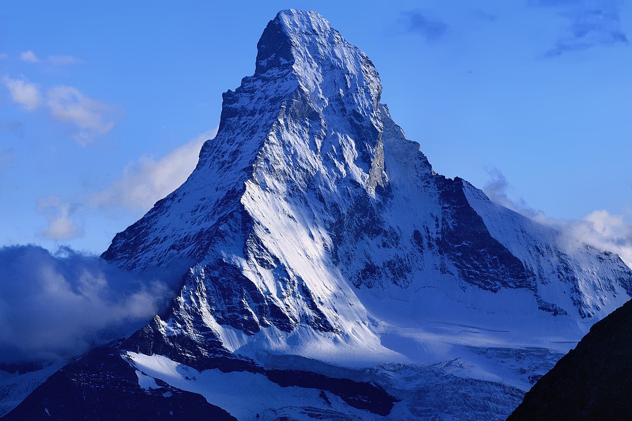
The Matterhorn rises to 4,478 metres on the border between Switzerland and Italy, straddling the main Alpine watershed in the Pennine Alps. Its pyramidal outline is formed by four steep faces separated by the Hörnli, Furggen, Zmutt and Leone, or Lion, ridges. The north, east and west faces lie on the Swiss side; the south face lies in Italy. Zermatt, in the canton of Valais, sits northeast of the mountain, while Breuil-Cervinia, in the Aosta Valley, lies to the south. Theodul Pass, just east of the peak, connects the valleys and has served as a trade passage since Roman times. These two valley towns provide different geographic starting points for planning a visit: choose the side that matches the intended mountain objective rather than treating them as interchangeable bases.
Choose between a valley visit, a trek and a summit climb
A Matterhorn trip does not have to be a summit attempt. Zermatt caters to hiking, skiing and mountaineering, with the mountain as its principal landmark. It is also a busy resort and more expensive than other destinations in the region, so the town experience and budget deserve attention alongside the outdoor plan. For a longer walking objective, trekkers undertake a circuit around the mountain described as a 10-day journey. That is a separate undertaking from climbing the peak. The most popular summit route starts from the Hörnli Hut and follows the northeast Hörnli ridge. Decide early whether the goal is hiking around the mountain or technical mountaineering on it; the prominence of the summit route does not make it an ordinary hiking option.
Steep terrain with a consequential climbing history
The Matterhorn’s climbing history is a useful warning against judging difficulty by familiarity. Edward Whymper’s party made the first ascent from Zermatt in 1865, but four of its seven climbers died in a fall during the descent. More than 500 alpinists are estimated to have died on the mountain. Its steep faces rise above glaciers, including the Matterhorn Glacier below the north face, and a summit plan needs to account for the descent as seriously as the ascent. The north face was first climbed in 1931; the west face, the tallest of the four, was completely climbed only in 1962. Glacial cirque erosion shaped the peak’s distinctive form. For visitors without the preparation for steep alpine terrain, a trip focused on valley-based activities is a different objective, not a lesser version of a summit attempt.
Route options
- Northeast Hörnli ridge
The most popular summit route climbs from the Hörnli Hut along the northeast ridge. Treat it as a mountaineering objective, with preparation for both the ascent and descent.
- Circuit around the Matterhorn
A trekking circuit around the mountain described as a 10-day journey. This is a multiday walking objective rather than a route to the summit.
Sample itineraries
- Zermatt-based Matterhorn visit · 2 days
Spend a suggested two days based in Zermatt, northeast of the Matterhorn. Focus on mountain views and hiking suited to current conditions and ability. Keep this separate from a summit attempt: the popular Hörnli ridge route is a mountaineering objective, not a casual extension of a town visit.
- Circuit around the Matterhorn · 10 days
Plan a 10-day trek around the mountain for a broader look at its Swiss and Italian setting. Establish the route, overnight stops and current conditions before committing; the circuit requires separate planning from a Zermatt-based visit or summit climb.
Seasonal conditions
Spring
Conditions-dependent; no fixed trekking window
Treat the high mountain as potentially wintry. Snow and freezing conditions can affect footing and access. Choose hiking plans only after checking local conditions, and do not assume valley conditions reflect those on the ridges.
Summer
Conditions-dependent; no guaranteed summit window
The Matterhorn remains a high-altitude mountain above glaciers. Plan hiking and mountaineering separately, and assess weather, snow and route conditions rather than relying on the season alone.
Fall
Conditions-dependent; reassess before departure
Allow for cold conditions and changes in mountain weather. Shorter daylight makes conservative turnaround decisions important. Confirm whether the intended trek or climb suits current conditions.
Winter
Winter; activity choice depends on conditions
Zermatt caters to skiing as well as hiking and mountaineering. Winter visits require cold-weather clothing and activity-specific planning; a ski-focused stay should not be treated as preparation for a Matterhorn ascent.
| Season | Window | Conditions |
|---|---|---|
| Spring | Conditions-dependent; no fixed trekking window | Treat the high mountain as potentially wintry. Snow and freezing conditions can affect footing and access. Choose hiking plans only after checking local conditions, and do not assume valley conditions reflect those on the ridges. |
| Summer | Conditions-dependent; no guaranteed summit window | The Matterhorn remains a high-altitude mountain above glaciers. Plan hiking and mountaineering separately, and assess weather, snow and route conditions rather than relying on the season alone. |
| Fall | Conditions-dependent; reassess before departure | Allow for cold conditions and changes in mountain weather. Shorter daylight makes conservative turnaround decisions important. Confirm whether the intended trek or climb suits current conditions. |
| Winter | Winter; activity choice depends on conditions | Zermatt caters to skiing as well as hiking and mountaineering. Winter visits require cold-weather clothing and activity-specific planning; a ski-focused stay should not be treated as preparation for a Matterhorn ascent. |
Permits, fees & closures
Confirm current permit and access requirements with the managing agency before trekking or climbing.
Confirm current permits, fees, and closures with the managing agency before you go.
Hazards & regulations
- Altitude: the summit reaches 4,478 metres. Allow time to acclimatize and descend if altitude symptoms develop.
- Steep, exposed terrain: all four faces are steep, and ridge climbing carries serious fall consequences. The descent requires sustained attention.
- Glaciated terrain: glaciers surround the mountain. Glacier travel requires appropriate skills, equipment and route assessment.
- High-mountain weather: cold, snow and reduced visibility can change the demands of a trek or climb. Keep plans flexible.
What to pack for Matterhorn
- Insulating layers
- Waterproof shell
- Warm hat and gloves
- Sun protection and sunglasses
- Footwear suited to the planned terrain
- Navigation tools
- Water and food
- Headlamp
- First-aid kit
- Climbing helmet and harness for mountaineering
- Route-appropriate rope and protection
- Ice axe and crampons where conditions require
- Glacier-travel equipment where applicable, with training to use it
Matterhorn FAQ
- Where is the Matterhorn?
- The Matterhorn straddles the Switzerland–Italy border in the Pennine Alps. It overlooks Zermatt in Switzerland's Valais to the northeast and Breuil-Cervinia in Italy's Aosta Valley to the south.
- How high is the summit?
- The summit is 4,478 metres above sea level. Its height, steep faces and surrounding glaciers make summit climbing a serious alpine undertaking.
- What is the most popular summit route?
- The northeast Hörnli ridge, approached from the Hörnli Hut, is the most popular summit route. Popularity does not make it a hiking route; climbers need suitable mountaineering skills and current route information.
- Can the mountain be visited without climbing it?
- Yes. Zermatt is a base for mountain views, hiking and skiing. Trekkers also undertake a 10-day circuit around the Matterhorn. Choose an activity that matches experience and conditions rather than making the summit the default goal.
- What should visitors expect in Zermatt?
- Zermatt caters heavily to skiing, hiking and mountaineering. It is busy and more expensive than other destinations in the region, so account for both crowds and cost when choosing a base.
- Which faces lie in Switzerland and Italy?
- The north, east and west faces lie on the Swiss side; the south face lies on the Italian side. The faces are separated by the Hörnli, Furggen, Zmutt and Leone, or Lion, ridges.