


Backpacking Trips · #8
Long Range Traverse
Newfoundland, Canada
Reader rating
Rate it and you move it. Community ratings re-rank this product inside its Top 10 list.
Expert-picked, reader-ranked. Our editors choose the products and the launch order; member star ratings move picks up or down over time.
35 km unmarked route in Gros Morne. Real navigation on tundra plateaus above the fjords.
Pros
- Unparalleled wilderness solitude and isolation
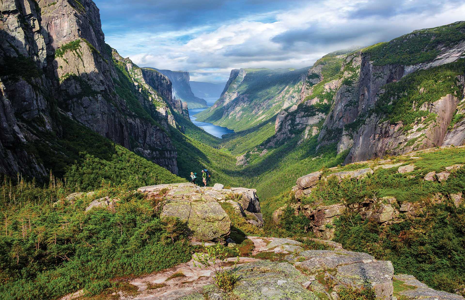
- Stunning panoramic fjord and mountain views
- Exceptional navigation challenge for experienced backpackers
- Abundant wildlife viewing opportunities (moose, caribou)
- Profound sense of accomplishment upon completion
Cons
- No marked trail, demanding advanced navigation skills
- Highly exposed to unpredictable weather (fog, rain, wind)
- Significant sections of boggy, uneven terrain
- Mandatory boat tour and permit booking adds logistical complexity
Best uses
- Experienced wilderness navigation
- Solitude and self-reliance
- Challenging multi-day trek
- Photography of remote landscapes
Specifications
- Location
- Gros Morne National Park, Newfoundland
- Distance
- 35 km
- Duration
- 3-5 days
- Navigation
- Unmarked, requires advanced skills
- Terrain
- Tundra, bog, rocky plateaus
- Permits
- Mandatory backcountry permit
- Access
- Ferry drop-off via Western Brook Pond
Best for
Experienced wilderness navigation, Solitude and self-reliance, Challenging multi-day trek, Photography of remote landscapes
The Long Range Traverse in Gros Morne National Park, Newfoundland, is not for the faint of heart or the unprepared. This 35-kilometer, unmarked backpacking route plunges you into the raw, untamed wilderness of the park's interior. It's a journey across exposed tundra plateaus, carved by glaciers, offering panoramic views of the spectacular fjords below. Unlike many national park trails, there is no signage, no established campsites, and very little in the way of human intervention once you leave the ferry drop-off. This is a true test of navigation skills, self-reliance, and preparedness for rapidly changing weather conditions. You're not just hiking; you're traversing, often through boggy terrain, over rocky outcrops, and across swift-flowing streams. What truly sets the Long Range Traverse apart is its profound sense of isolation and the feeling of stepping back into a primeval landscape. Wildlife encounters are common, from moose and caribou to black bears. The challenge lies not just in the physical exertion but in the mental fortitude required to navigate by map and compass, or GPS, through featureless sections of the plateau. It demands respect for nature's power and a solid understanding of backcountry safety. This isn't a trip to be undertaken lightly; it requires proper planning, appropriate gear, and a healthy dose of humility in the face of Newfoundland's rugged beauty.
Geography and Terrain
The traverse navigates the ancient Long Range Mountains, a northern extension of the Appalachians, characterized by vast, treeless tundra plateaus. These high elevations are dotted with countless ponds and boggy sections, remnants of glacial activity. The route offers dramatic vistas as it skirts the edges of deep, U-shaped fjords like Western Brook Pond. Expect significant elevation changes, but not in the form of continuous, steep climbs; rather, it’s an undulating landscape with numerous small rises and descents, often through thick brush or across uneven, rocky ground. The true challenge is the lack of a defined path, forcing constant route-finding.
Best Season and Weather
The optimal window for the Long Range Traverse is typically late June to early September. Before late June, snow patches can persist, and stream crossings are higher. By mid-September, weather becomes highly unpredictable, with increased chances of cold, driving rain, fog, and even early snow. Even in summer, prepare for all four seasons in a single day: bright sunshine can quickly give way to dense fog, strong winds, and chilling rain. Pack layers, waterproofs, and be ready to hunker down if conditions turn foul. Visibility can drop to near zero in fog, making navigation even more critical.
Wildlife Encounters
This remote wilderness is prime habitat for a variety of wildlife. Moose are abundant, often spotted grazing in marshy areas or by ponds. Caribou herds roam the plateaus, offering a truly wild experience. Black bears are also present, so proper food storage (bear canister or hanging food) is non-negotiable. Other animals you might spot include arctic hares, red foxes, and various bird species, including bald eagles soaring overhead. Maintaining a respectful distance and understanding bear safety protocols are essential for both your safety and the well-being of the animals.
Routes and Attractions
The Long Range Traverse begins with a mandatory boat tour across Western Brook Pond, where you are dropped off at a designated point. From there, the 'route' is largely up to you, guided by topographical maps and GPS waypoints. Key attractions are the stunning fjord views, particularly from the 'Big Table' and other high points overlooking the pond. The journey is the attraction: the challenge of navigation, the solitude, and the raw, untouched beauty of the landscape. There are no specific 'sights' in the traditional sense; the entire traverse is a continuous, immersive experience in wilderness travel.
Permits and Access
Access to the Long Range Traverse is strictly controlled by Parks Canada. A mandatory backcountry permit is required, which includes a briefing on safety and leave no trace principles. You must demonstrate proficiency in map and compass navigation during this briefing, and often carry a GPS. Access to the trailhead itself involves booking a boat tour across Western Brook Pond, which drops hikers at the start point. There are quotas for the number of groups allowed on the traverse at any given time, so early booking for both the permit and the boat tour is highly recommended.
How we chose
We built this ranking from trip reports, agency data, permit records, and our editors' own time on the ground. 10 places made the final cut out of a much longer working list, and each one had to clear the same set of criteria before it earned a spot.
- Quality of the terrain
- Landscape, route variety, and whether the place rewards multiple days rather than one overlook.
- Season and weather windows
- How long the reliable window is, and how badly the shoulder seasons punish a bad forecast.
- Access and permits
- Trailhead logistics, permit odds, quotas, and how much lead time a trip realistically takes.
- Solitude vs. crowding
- How far you have to walk before the place feels like wilderness instead of a queue.
- Wildlife and ecology
- What you can reasonably expect to see, and what you have to plan around.
- Risk and skill required
- Navigation, water crossings, exposure, and rescue distance — stated plainly.
Long Range Traverse — frequently asked questions
- Is Long Range Traverse worth the trip?
- We rank it #8 in Backpacking Trips. 35 km unmarked route in Gros Morne. Real navigation on tundra plateaus above the fjords.
- Who is Long Range Traverse best for?
- Best for experienced wilderness navigation, solitude and self-reliance, challenging multi-day trek and photography of remote landscapes. Standouts: unparalleled wilderness solitude and isolation and stunning panoramic fjord and mountain views.
- What are the drawbacks of Long Range Traverse?
- No marked trail, demanding advanced navigation skills, Highly exposed to unpredictable weather (fog, rain, wind) and Significant sections of boggy, uneven terrain.
- What are the key details for Long Range Traverse?
- Location: Gros Morne National Park, Newfoundland · Distance: 35 km · Duration: 3-5 days · Navigation: Unmarked, requires advanced skills · Terrain: Tundra, bog, rocky plateaus
- Geography and Terrain — what should I know about the Long Range Traverse?
- The traverse navigates the ancient Long Range Mountains, a northern extension of the Appalachians, characterized by vast, treeless tundra plateaus. These high elevations are dotted with countless ponds and boggy sections, remnants of glacial activity.
- Best Season and Weather — what should I know about the Long Range Traverse?
- The optimal window for the Long Range Traverse is typically late June to early September. Before late June, snow patches can persist, and stream crossings are higher.
Where on earth
Satellite imagery flying in from a world view to Long Range Traverse, Newfoundland and Labrador, Canada. Use the + / − buttons, or click the map to zoom with your scroll wheel; drag to pan and pinch to zoom on touch.
Long Range Mountains, Newfoundland and Labrador A0K 1H0, Canada · 50.417, -57.167
Wildlife found around Long Range Traverse








Compare side by side
Put the Long Range Traverse against any other pick on this list — specs, price, pros, cons and reader ratings.