


Where on earth
Satellite imagery flying in from a world view to Wyoming Peak Summit via Middle Piney Lake, United States. Use the + / − buttons, or click the map to zoom with your scroll wheel; drag to pan and pinch to zoom on touch.
- Region
- Wyoming
- Country
- United States
- Trip length
- 9 miles round trip
- Backpacking
- Hiking
- Climbing
- Mountaineering
- Winter Camping
- Skiing
- Desert Hiking
- Canyoneering
Key takeaways
- Trip length: 9 miles round trip
- Top activity: backpacking
Topic summary
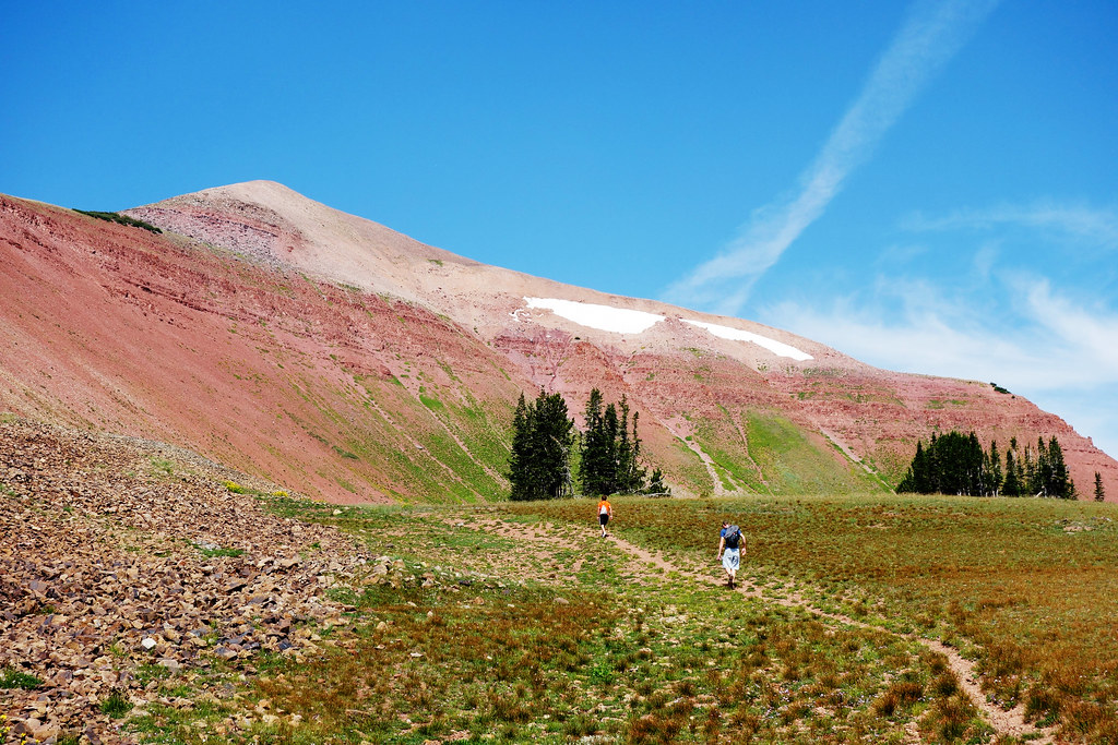
High-ridge alpine route reaching the 11,378-foot crest of the Wyoming Range.
Intended uses
backpacking
Verification notes
Last verified October 17, 2026.
Tools for a trip here
Picked for how, when and where you're going. Free, no signup.
- Sleep System Temp CalculatorCold nights: check your bag and pad add up to a safe sleep.
- Bear Country Food StorageBear country: canister, Ursack or hang, and the local rules.
- Base Weight CalculatorEvery ounce is carried — total your kit and find your base weight.
- Pack Volume SizerSize the pack for your trip length and season.
- Water Purification MatrixTreat water from streams and lakes on trail.
Plan with verified data
Wyoming Peak Summit via Middle Piney Lake trip tools
How to get there
From Big Piney, head west on Wyoming State Highway 350 for approximately 10 miles, where it becomes County Road 111/Middle Piney Road. Continue another 10 miles to Bridger-Teton National Forest, where the road becomes FS 10046. Follow FS 10046 for approximately 2 miles, then veer left onto FS 10024 toward Middle Piney Lake. After approximately 0.75 miles, veer left again to remain on FS 10024. Continue 4 miles to the trailhead at the road's end. The approximate drive from Big Piney is 26 miles and 42 minutes. Trailhead coordinates: 42.602869, -110.564997.
- Middle Piney Lake Trailhead
The hiking and horseback-riding access point for connecting trails toward Wyoming Peak, Wohelo Falls, and the Wyoming Range National Recreation Trail. Located at the end of FS 10024, with restrooms nearby but no potable water.
- Big Piney
The town gateway for the road approach, not a separate summit trailhead. Head west on WY 350 to begin the drive toward Middle Piney Lake.
Sources: fs.usda.gov · Wikipedia · Wikivoyage. Confirm road and trailhead conditions with the managing agency before you leave.
Popular pursuits at Wyoming Peak Summit via Middle Piney Lake
- Backpacking
Multi-day travel with everything on your back — see the packing blocks below.
- Hiking
Day miles on marked trail, with route notes and trail links below.
- Climbing
Rock and alpine lines with approach beta.
- Mountaineering
Glacier and high-route objectives with real consequence.
- Winter Camping
Cold-season travel and camp craft; layering matters more than mileage.
- Skiing
Ski-touring access when the road closes for the season.
Animals around Wyoming Peak Summit via Middle Piney Lake








Maps, GPS & compass for this trip
Carry a waterproof paper map and a compass you can steer by, and treat the GPS as the backup — not the other way round. Buying links go to Amazon; Wild10 earns a commission at no cost to you.
Waterproof topo maps
- Waterproof topographic map — Wyoming Peak Summit via Middle Piney LakeAmazon search for waterproof, tear-resistant topo maps covering this area.
- National Geographic Trails IllustratedThe waterproof Trails Illustrated series — check for a sheet covering this area.
- Waterproof map case & compass lanyardKeep a paper map readable in rain, spray and a swamped boat.
Fishing at Wyoming Peak Summit via Middle Piney Lake
Planning to fish Wyoming Peak Summit via Middle Piney Lake? Fishing licenses, open seasons and catch limits in Wyoming are set by the local wildlife authority and change every year — check the official source before you cast a line.
Do I need a fishing license at Wyoming Peak Summit via Middle Piney Lake?
- A Wyoming fishing license is normally required for anyone over the local youth age.
- Read the current Wyoming fishing regulations for special waters, barbless-hook or catch-and-release rules.
- Clean, drain and dry boats and gear between waters to stop invasive species.
Hunting near Wyoming Peak Summit via Middle Piney Lake
Thinking about hunting Wyoming Peak Summit via Middle Piney Lake? Hunting seasons, tags and draws in Wyoming are set by the wildlife authority each year. Confirm the rules for your species and unit before you go.
Is hunting allowed at Wyoming Peak Summit via Middle Piney Lake?
- Confirm the land around Wyoming Peak Summit via Middle Piney Lake is open to hunting and which management unit it falls in.
What do I need to hunt in Wyoming?
- A Wyoming hunting license — most jurisdictions also require hunter education certification.
- Species tags or draw results for big game such as deer, elk, moose or bear where they occur.
- Knowledge of firearm and bow transport rules, which differ by land type and border crossing.
Wyoming Peak from Middle Piney Lake
Middle Piney Lake Trailhead provides access to Wyoming Peak and the top of the Wyoming Range in Bridger-Teton National Forest. This is a starting point for both hikers and horseback riders, with connecting trails also reaching Wohelo Falls and the Wyoming Range National Recreation Trail. For a summit-focused visit, distinguish the drive to Middle Piney Lake from the mountain route beyond it: reaching the trailhead is only the approach. Before setting out, obtain a current trail map and confirm the junctions leading toward Wyoming Peak with the Big Piney Ranger District. Plan the outing around the ability of the whole group, carry navigation tools, and leave enough time to return without depending on an assumed summit pace.
Trailhead facilities and preparation
Middle Piney Lake Trailhead is open 24 hours a day, and no fees are required at the site. Restrooms are available nearby, but there is no potable water at the trailhead. Bring drinking water for the outing rather than expecting to fill bottles on arrival; if planning to use natural water, carry a treatment method. The trailhead serves day hiking, backpacking, and horseback riding, so be prepared to share the approach with horses and give riders room to pass safely. For travel toward the top of the Wyoming Range, pack layers and weather protection suited to a mountain outing. Check current conditions before leaving Big Piney, and keep the summit optional if conditions or the group's energy change.
Access planning and local checks
The road approach begins in Big Piney and follows a sequence of highway, county road, and Forest Service road segments to Middle Piney Lake. Pay attention to the road-number changes and the two left forks rather than relying only on the lake name. The approximate trip from town is 26 miles and 42 minutes; treat that timing as an estimate, not a guarantee. Big Piney Ranger District is the contact for the trailhead at 307-276-5800. Before departure, confirm road and trail conditions, any permit requirements for the planned activity, and applicable food-storage and camping rules. If combining the summit with an overnight trip, check those requirements separately rather than assuming that the trailhead's no-fee status covers every part of the visit.
Route options
- Wyoming Peak via Middle Piney Lake
Use Middle Piney Lake Trailhead to access connecting trails toward Wyoming Peak and the top of the Wyoming Range. Confirm the summit route and junctions with a current map and the Big Piney Ranger District before departure.
- Wohelo Falls connection
Trails connecting to Middle Piney Lake also provide access to Wohelo Falls, offering a different destination from the summit. Confirm the route before choosing it as an alternative outing.
- Wyoming Range National Recreation Trail connection
Access the Wyoming Range National Recreation Trail through trails connecting to Middle Piney Lake. Choose the intended segment and turnaround using a current trail map.
Sample itineraries
- Wyoming Peak summit attempt · 1 day
Start at Middle Piney Lake Trailhead and use connecting trails toward Wyoming Peak. Confirm the route, mileage, elevation gain, and current conditions with the Big Piney Ranger District before committing to a day trip. Set a turnaround time that leaves enough daylight for the return.
- Wohelo Falls and Wyoming Peak · 2 days
Plan separate outings from Middle Piney Lake Trailhead: Wohelo Falls on the first day and a Wyoming Peak summit attempt on the second. Confirm both routes and their demands beforehand. Arrange overnight accommodation separately; do not assume camping is available at the trailhead.
Seasonal conditions
Spring
Spring; confirm road and trail conditions before departure
For a route reaching the top of the Wyoming Range, check for lingering snow and wet footing before attempting the summit. Confirm that the approach roads are usable; 24-hour trailhead operating hours do not establish seasonal road conditions.
Summer
Summer; choose a suitable mountain-weather forecast
Plan around the forecast rather than assuming summer guarantees safe summit conditions. Carry water from the start because potable water is unavailable at the trailhead. Leave enough daylight for route-finding and the return.
Fall
Fall; reassess conditions before each outing
Allow for shorter daylight and potentially colder mountain conditions. Check for snow or ice before heading toward Wyoming Peak, and carry layers suitable for a delayed return.
Winter
Winter; verify access and route suitability
Do not assume the summer hiking approach remains practical. Ask the Big Piney Ranger District about road access and snow conditions before planning a visit. Treat a summit attempt as dependent on conditions, equipment, and winter mountain experience.
| Season | Window | Conditions |
|---|---|---|
| Spring | Spring; confirm road and trail conditions before departure | For a route reaching the top of the Wyoming Range, check for lingering snow and wet footing before attempting the summit. Confirm that the approach roads are usable; 24-hour trailhead operating hours do not establish seasonal road conditions. |
| Summer | Summer; choose a suitable mountain-weather forecast | Plan around the forecast rather than assuming summer guarantees safe summit conditions. Carry water from the start because potable water is unavailable at the trailhead. Leave enough daylight for route-finding and the return. |
| Fall | Fall; reassess conditions before each outing | Allow for shorter daylight and potentially colder mountain conditions. Check for snow or ice before heading toward Wyoming Peak, and carry layers suitable for a delayed return. |
| Winter | Winter; verify access and route suitability | Do not assume the summer hiking approach remains practical. Ask the Big Piney Ranger District about road access and snow conditions before planning a visit. Treat a summit attempt as dependent on conditions, equipment, and winter mountain experience. |
Permits, fees & closures
Confirm any permit requirements for your planned summit outing or overnight stay with the Big Piney Ranger District at 307-276-5800.
Fees: No fees are required at Middle Piney Lake Trailhead.
Official source: Bridger-Teton National Forest | Middle Piney Lake Trailhead · Verified October 17, 2026
Hazards & regulations
- No potable water is available at the trailhead. Bring enough drinking water and treatment equipment if planning to use natural sources.
- Mountain weather can make a summit outing unsuitable. Check the forecast, carry protective layers, and turn back if conditions worsen.
- Connecting trails require route planning. Confirm the Wyoming Peak route and carry navigation tools rather than relying on the destination name alone.
- Hikers and horseback riders share access from Middle Piney Lake Trailhead. Give horses space and communicate with riders before passing.
- Check current food-storage requirements before carrying food or camping in the Big Piney Ranger District.
What to pack for Wyoming Peak Summit via Middle Piney Lake
- Trail map covering Middle Piney Lake and Wyoming Peak
- Compass or offline navigation
- Headlamp
- First-aid kit
- Emergency shelter
- Insulating layer
- Waterproof shell
- Sturdy hiking footwear
- Warm hat and gloves
- Drinking water carried from the start
- Water-treatment equipment
- Food and extra snacks
- Food storage meeting current district requirements
Wyoming Peak Summit via Middle Piney Lake FAQ
- How do you reach Middle Piney Lake Trailhead?
- From Big Piney, follow WY 350 west as it becomes County Road 111/Middle Piney Road, then FS 10046. Turn left onto FS 10024 and stay left at the next fork. Continue to the road's end. The drive is approximately 26 miles and 42 minutes from Big Piney.
- Is the trailhead open around the clock?
- Listed operating hours are 24 hours a day. Check current road and trail conditions separately before traveling, especially when snow may affect access.
- Are water and restrooms available?
- Restrooms are available nearby, but there is no potable water at the trailhead. Arrive with drinking water.
- How long is the Wyoming Peak summit hike?
- Confirm round-trip mileage, elevation gain, route details, and expected travel time with the Big Piney Ranger District at 307-276-5800 before deciding whether the summit fits your group and available daylight.
- What other destinations connect to this trailhead?
- Connecting trails provide access to Wohelo Falls and the Wyoming Range National Recreation Trail, as well as Wyoming Peak. Confirm individual route details before adding an extension.
- Can horseback riders use this access?
- Yes. Middle Piney Lake Trailhead provides access for hikers and horseback riders to the top of the Wyoming Range.