


Where on earth
Satellite imagery flying in from a world view to Samaria Gorge (Crete), Greece. Use the + / − buttons, or click the map to zoom with your scroll wheel; drag to pan and pinch to zoom on touch.
- Region
- Greece
- Biome
- Mediterranean gorge (0–1,250 m)
- Best season
- May – October
- Difficulty
- moderate
- Backpacking
- Hiking
Key takeaways
- Biome: Mediterranean gorge (0–1,250 m)
- Best season: May – October
- Difficulty: moderate
- Top activity: backpacking
Photos of Samaria Gorge (Crete)
Topic summary
A 16-km one-way walk through Europe's longest gorge in Crete's White Mountains.
Key takeaways
- Difficulty: moderate
- Best season: May – October
Intended uses
backpacking
Climate suitability
Mediterranean gorge (0–1,250 m)
Tools for a trip here
Picked for how, when and where you're going. Free, no signup.
- Sleep System Temp CalculatorCold nights: check your bag and pad add up to a safe sleep.
- Base Weight CalculatorEvery ounce is carried — total your kit and find your base weight.
- Pack Volume SizerSize the pack for your trip length and season.
- Water Purification MatrixTreat water from streams and lakes on trail.
- Layering CalculatorCold-season miles: layer for climbs and camp.
Plan with verified data
Samaria Gorge (Crete) trip tools
How to get there
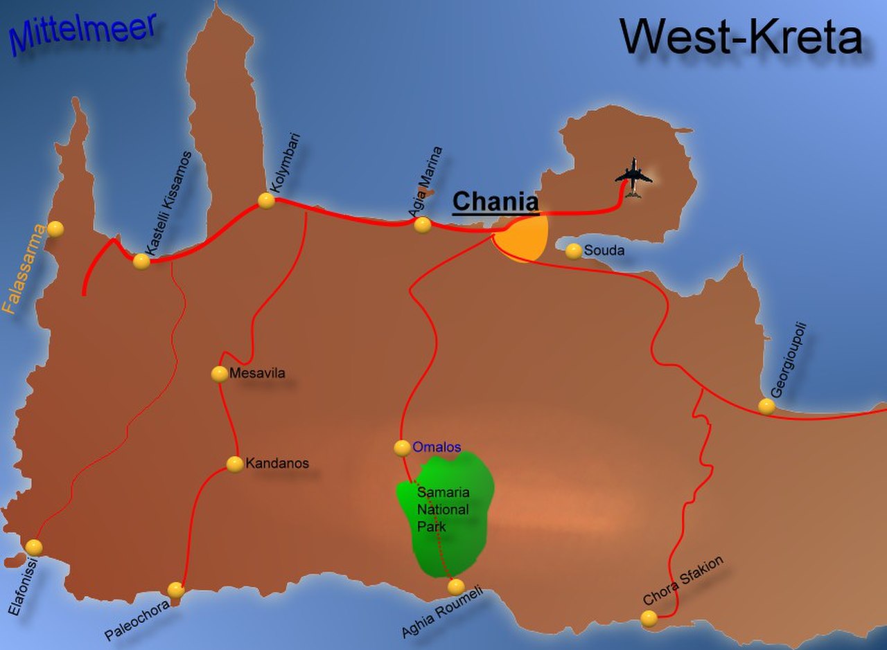
Reach the northern entrance near Omalos by bus or organized transfer. For the through-walk, finish at Agia Roumeli and continue by ferry east to Chora Sfakion or west toward Sougia or Paleochora. Organized tours can include connecting buses after the ferry; independent travelers should confirm current services and onward connections before departure.
- Northern entrance near Omalos
The starting point for the standard downhill through-walk, at an altitude of 1,250 meters near the Omalos plateau. Organized trips provide bus transport to this entrance.
- Agia Roumeli
The coastal finish on the Libyan Sea, two kilometers beyond the park exit, and the starting point for the out-and-back walk to the Gates. Ferry connections link the village with Chora Sfakion, Sougia, and Paleochora.
Sources: Wikipedia · Wikivoyage. Confirm road and trailhead conditions with the managing agency before you leave.
Popular pursuits at Samaria Gorge (Crete)
- Backpacking
Multi-day travel with everything on your back — see the packing blocks below.
- Hiking
Day miles on marked trail, with route notes and trail links below.
Animals around Samaria Gorge (Crete)
Maps, GPS & compass for this trip
Carry a waterproof paper map and a compass you can steer by, and treat the GPS as the backup — not the other way round. Buying links go to Amazon; Wild10 earns a commission at no cost to you.
Waterproof topo maps
- Waterproof topographic map — Samaria Gorge (Crete)Amazon search for waterproof, tear-resistant topo maps covering this area.
- National Geographic Trails IllustratedThe waterproof Trails Illustrated series — check for a sheet covering this area.
- Waterproof map case & compass lanyardKeep a paper map readable in rain, spray and a swamped boat.
Fishing at Samaria Gorge (Crete)
Planning to fish Samaria Gorge (Crete), Greece? Fishing licences, open seasons and catch limits in Greece are set by the local wildlife authority and change every year — check the official source before you cast a line.
Do I need a fishing licence at Samaria Gorge (Crete)?
- A Greece fishing licence is normally required for anyone over the local youth age.
- Read the current Greece fishing regulations for special waters, barbless-hook or catch-and-release rules.
- Clean, drain and dry boats and gear between waters to stop invasive species.
We don't have a verified licensing link on file for Greece yet — contact the park or land manager listed on this page for current hunting and fishing rules.
Hunting near Samaria Gorge (Crete)
Thinking about hunting Samaria Gorge (Crete), Greece? Hunting seasons, tags and draws in Greece are set by the wildlife authority each year. Confirm the rules for your species and unit before you go.
Is hunting allowed at Samaria Gorge (Crete)?
- Confirm the land around Samaria Gorge (Crete) is open to hunting and which management unit it falls in.
What do I need to hunt in Greece?
- A Greece hunting licence — most jurisdictions also require hunter education certification.
- Species tags or draw results for big game such as deer, elk, moose or bear where they occur.
- Knowledge of firearm and bow transport rules, which differ by land type and border crossing.
We don't have a verified licensing link on file for Greece yet — contact the park or land manager listed on this page for current hunting and fishing rules.
A mountain-to-sea walk in southwest Crete
Samaria Gorge cuts through southwest Crete in the Chania region, between the White Mountains and Mount Volakias. A small river formed the gorge, and the standard walk descends from the northern entrance near the Omalos plateau toward Agia Roumeli on the Libyan Sea. The entrance stands at 1,250 meters, giving the outing a distinctly mountain-to-coast character. Allow five to seven hours for the walk, which can be strenuous, particularly at the height of summer. Distance figures need care: the walking route covers 13 kilometers inside the national park, followed by another two kilometers to Agia Roumeli. Plan for that full 15-kilometer journey rather than treating the park exit as the end of the day. The onward sea connection is an essential part of planning a through-walk.
The Gates, wildlife, and the former village
The best-known stretch is the Gates, where the gorge narrows to just four meters and its walls rise almost 300 meters. This is the defining feature of the lower-gorge out-and-back from Agia Roumeli, as well as a landmark on the full descent. Samaria became a national park in 1962, particularly to protect the rare kri-kri, or Cretan goat. The gorge and surrounding country also support endemic species, flowers, and birds, so leave plants undisturbed and give wildlife space rather than approaching for photographs. The former village of Samaria lies inside the gorge. Its last residents left in 1962 to make way for the park. Both the village and the gorge take their names from the village's ancient church, Ossia Maria, adding a human history to the mountain landscape.
Plan the walk around the onward journey
The full descent is a point-to-point outing, so arrange both the approach to Omalos and the departure from Agia Roumeli before setting off. Organized trips combine a bus to the northern entrance with onward bus transport after the ferry crossing to Sougia or Chora Sfakion. Independent day trips are also possible from Chania, Sougia, or Paleochora, but current bus and ferry connections need checking before committing to a walking plan. Avoid building a tight itinerary around the fastest walking estimate: summer conditions can make the descent more demanding, and the final two kilometers beyond the park still have to be covered. Carry water, food, sun protection, and footwear suited to a long gorge walk. For an alternative without the full mountain descent, consider the return walk from Agia Roumeli to the Gates.
Route options
- Northern entrance to Agia Roumeli15 km: 13 km inside the park, plus 2 km to Agia RoumeliCan be strenuous, especially at the peak of summer.
Descend from near Omalos through Samaria National Park and the Gates, then continue from the park exit to the coast. Allow five to seven hours and plan an onward ferry connection.
- Agia Roumeli to the Gates and back
Approach the gorge from Agia Roumeli, walk to the narrow Gates, and return to the village. This offers an alternative to the full descent from the Omalos plateau.
Sample itineraries
- Omalos to Agia Roumeli · 1 day
Descend from the northern entrance near Omalos through Samaria Gorge to Agia Roumeli. Allow five to seven hours for the strenuous walk: 13 km through the park plus 2 km to the village. Arrange onward ferry travel to Sougia or Hora Sfakion and confirm connecting transport.
- Gorge descent with a coastal overnight · 2 days
Walk from Omalos to Agia Roumeli on day one, then take a ferry to Sougia or Hora Sfakion and stay overnight. Return toward Chania on day two. Confirm ferry, accommodation, and coach arrangements before starting.
- Agia Roumeli to the Gates · 1 day
Approach the gorge from Agia Roumeli, walk to the Gates, and return the same way. This avoids the full descent from Omalos. Confirm current access and allow enough time for the return walk and any onward ferry.
Seasonal conditions
Spring
Spring; confirm current access before planning
The route connects a mountain entrance at 1,250 m with the Libyan Sea. Pack layers for changing conditions between elevations, and check local weather rather than assuming coastal conditions apply throughout the gorge.
Summer
Summer, especially peak summer
The five-to-seven-hour descent can be particularly strenuous at the height of summer. Carry sufficient water, sun protection, and food, and leave room in the day's transport plan for a slower pace.
Fall
Fall; confirm current access before planning
Plan around the mountain-to-coast setting and a long walking day. Check the local forecast and onward transport before committing; seasonal access and service availability need confirmation.
Winter
Winter; confirm current access before planning
Crete has rugged mountain peaks, some retaining snow through much of the year. Do not judge conditions at the elevated northern entrance from coastal weather. Verify gorge access and mountain conditions before setting out.
| Season | Window | Conditions |
|---|---|---|
| Spring | Spring; confirm current access before planning | The route connects a mountain entrance at 1,250 m with the Libyan Sea. Pack layers for changing conditions between elevations, and check local weather rather than assuming coastal conditions apply throughout the gorge. |
| Summer | Summer, especially peak summer | The five-to-seven-hour descent can be particularly strenuous at the height of summer. Carry sufficient water, sun protection, and food, and leave room in the day's transport plan for a slower pace. |
| Fall | Fall; confirm current access before planning | Plan around the mountain-to-coast setting and a long walking day. Check the local forecast and onward transport before committing; seasonal access and service availability need confirmation. |
| Winter | Winter; confirm current access before planning | Crete has rugged mountain peaks, some retaining snow through much of the year. Do not judge conditions at the elevated northern entrance from coastal weather. Verify gorge access and mountain conditions before setting out. |
Permits, fees & closures
Confirm entry requirements and current access with the national park managing agency.
Confirm current permits, fees, and closures with the managing agency before you go.
Hazards & regulations
- The full park-to-village hike is 15 km and takes five to seven hours; fatigue can become significant before reaching Agia Roumeli.
- Peak-summer conditions can make the descent especially strenuous. Plan water, sun protection, and pacing accordingly.
- The northern entrance sits at 1,250 m, well above the coastal finish. Prepare for changing weather and temperatures along the descent.
- The Gates narrow to only four meters between walls almost 300 meters high. Stay attentive while moving through the constricted passage.
- Onward travel from Agia Roumeli involves ferry connections. Confirm current services and leave enough time to avoid missing transport.
What to pack for Samaria Gorge (Crete)
- Supportive walking footwear
- Comfortable daypack
- Food and snacks for a five-to-seven-hour hike
- Route information available offline
- Sufficient drinking water
- Sun hat and sunscreen
- Layers for the elevated entrance and coastal finish
- Weather protection suited to the forecast
- Basic first-aid kit
- Charged phone
- Confirmed ferry and onward transport details
- Overnight essentials if staying in Sougia or Hora Sfakion
Wildlife you may see
- The rare kri-kri, or Cretan goat, was a central reason for establishing the national park. Observe without approaching or feeding.
- The gorge and surrounding area support other endemic species, along with varied flowers and birds. Avoid disturbing wildlife or picking plants.
Samaria Gorge (Crete) FAQ
- Where is Samaria Gorge?
- Samaria Gorge lies in southwest Crete, in the regional unit of Chania. A small river formed it between the White Mountains and Mt. Volakias, with the walking route finishing at Agia Roumeli on the Libyan Sea.
- How long is the hike?
- The walk through the national park is 13 km, followed by another 2 km to Agia Roumeli: 15 km altogether. Allow five to seven hours. The commonly quoted 18 km refers to the distance between Omalos settlement and Agia Roumeli.
- How does the return journey work?
- After reaching Agia Roumeli, hikers can take a ferry to Sougia or Hora Sfakion, then connect with transport toward Chania or stay overnight. Organized trips can coordinate buses and ferries. Independent travelers should confirm current connections before departure.
- Is there an alternative to the full descent?
- Yes. A route runs from Agia Roumeli to the Gates and back. Confirm access and plan the return walk around onward transport; do not assume this option requires no preparation.
- What are the Gates?
- The Gates are the gorge's best-known narrow section. The walls close to just four meters apart and rise almost 300 meters. They are sometimes called the Iron Gates, though that name is inaccurate.
- What is the abandoned village inside the gorge?
- Samariá village lies inside the gorge. Its last residents left in 1962 to make way for the national park. Both the village and gorge take their names from the village's ancient church, Óssia María.