


Adventure Locations · #1
Boundary Waters Canoe Area Wilderness
Minnesota, USA
Reader rating
Rate it and you move it. Community ratings re-rank this product inside its Top 10 list.
Expert-picked, reader-ranked. Our editors choose the products and the launch order; member star ratings move picks up or down over time.
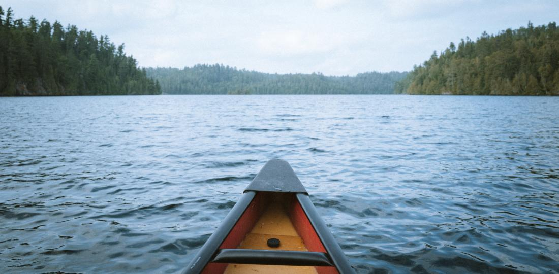
Over a million acres of interconnected lakes and portages. The archetypal North American canoe country.
Pros
- Unparalleled solitude and immersion in nature
- Extensive network of paddleable waterways
- Rich wildlife viewing opportunities
- Profound sense of self-reliance and adventure
- Stunning boreal forest and lake scenery
Cons
- Requires physical effort for portaging
- Can be crowded at popular entry points in peak season
- Intense insect pressure in late spring/early summer
- Demands complete self-sufficiency and preparedness
Best uses
- Multi-day canoe camping
- Wildlife photography
- Paddle fishing expeditions
- Backcountry solitude
- Family wilderness trips
Specifications
- Location
- Northeastern Minnesota, USA
- Size
- Over 1 Million Acres
- Primary Activity
- Canoe Camping, Portaging
- Key Feature
- Interconnected Lake & River System
- Permits Required
- Yes, Quota System
- Motorboats
- Restricted on Most Lakes
Best for
Multi-day canoe camping, Wildlife photography, Paddle fishing expeditions, Backcountry solitude, Family wilderness trips
The Boundary Waters Canoe Area Wilderness (BWCAW) in northern Minnesota stands as a quintessential North American wilderness experience, encompassing over a million acres of pristine lakes, rivers, and dense forests. This vast, roadless expanse is renowned for its intricate network of waterways, carved by glaciers millennia ago, offering unparalleled opportunities for canoe camping and silent sports. Its designation as a wilderness area means motorboats are restricted on most lakes, ensuring a profound sense of solitude and immersion in nature. Visitors navigate by paddle and portage, carrying their canoes and gear between lakes, replicating the age-old journeys of Indigenous peoples and early European fur traders. The landscape is characterized by granite outcrops, towering pine and spruce forests, and an abundance of clean, clear water, reflecting the wild beauty of the Canadian Shield. Accessibility is primarily through designated entry points, each requiring a permit to regulate visitor numbers and preserve the wilderness character. The BWCAW's sheer scale allows for endless exploration, from short weekend trips to multi-week expeditions, catering to various skill levels. It's a place where modern distractions fade, replaced by the rhythm of paddling, the crackle of a campfire, and the call of a loon. The area demands self-sufficiency and respect for its delicate ecosystem, providing a challenging yet deeply rewarding escape for those seeking genuine backcountry adventure. Preparation is key, as services are non-existent once inside the wilderness boundary, emphasizing leave-no-trace principles.
Geography and Terrain
The BWCAW's geography is defined by the Canadian Shield, characterized by ancient, exposed bedrock, boreal forests, and an estimated 1,200 lakes and hundreds of miles of rivers and streams. This glacially sculpted landscape features myriad islands, narrow channels, and rocky shores. Portages, often short but sometimes challenging, connect these waterways, requiring campers to carry their canoes and gear. The elevation changes are generally subtle, but the terrain can be rugged underfoot on portage trails. Expect a mix of pine, spruce, birch, and aspen forests, with wetlands and bogs filling lower areas. The water is generally clean and clear, though tannin-stained in some areas from decaying vegetation.
Best Season and Weather
The ideal time to visit the BWCAW is typically from late May through early October. June offers longer daylight hours and generally pleasant temperatures, though black flies and mosquitoes can be intense. July and August are warmer and drier, perfect for swimming, but also the busiest months. Early fall, from September to early October, brings vibrant fall colors, fewer insects, and crisp, cool weather, though nighttime temperatures can drop significantly. Spring (April/May) and late fall (late Oct/Nov) can be challenging due to cold water, unpredictable weather, and ice conditions. Winters offer opportunities for ice fishing and cross-country skiing, but require specialized skills and gear.
Wildlife Encounters
The BWCAW is home to a diverse array of wildlife, offering excellent viewing opportunities for observant visitors. Common sightings include moose, black bears, timber wolves, white-tailed deer, and various small mammals like beavers, otters, and red foxes. Birdwatching is superb, with bald eagles, ospreys, and several species of owls and waterfowl, most notably the iconic common loon, whose haunting calls define the wilderness soundscape. Fishing is a major draw, with abundant walleye, northern pike, smallmouth bass, and lake trout. It's crucial to practice proper food storage to avoid bear encounters and maintain a respectful distance from all wildlife.
Key Routes and Attractions
There are countless routes through the BWCAW, ranging from easy loops to extensive expeditions. Popular entry points include Lake One, Saganaga Lake, and Moose Lake, offering access to well-traveled circuits. Some routes lead to notable attractions like the pictographs on Crooked Lake, ancient rock art from the area's Indigenous inhabitants, or the challenging portages of the Grand Portage. Every lake and campsite holds its own appeal, from sandy beaches to rocky overlooks. The wilderness itself, with its quiet waters and star-filled nights, is the primary attraction. It encourages exploration and self-discovery rather than focusing on specific landmarks.
Permits and Access
Access to the BWCAW is strictly controlled by a quota permit system, issued by the U.S. Forest Service. Permits are required for all overnight trips and for day-use motorboat trips on designated lakes. They can be reserved online months in advance, and competition for prime entry points and dates can be fierce. Each permit specifies an entry point and date, and groups must enter on that date. Only a limited number of groups are allowed to enter each day at each entry point, ensuring solitude. Self-issued permits are available for day-use paddle trips. Adhering to leave-no-trace principles is mandatory.
Honest Trade-offs
While offering unmatched wilderness, the BWCAW does present a few trade-offs. Popular entry points and routes can experience moderate crowds, especially during peak summer months, diminishing the sense of solitude. The necessity of portaging, while integral to the experience, can be physically demanding, particularly with heavy gear or on rugged trails. Insect pressure, especially mosquitoes and black flies, can be intense from late spring through mid-summer, requiring diligent bug protection. Weather can change rapidly, and strong winds can create dangerous conditions on large lakes. There are no facilities or services within the wilderness, demanding complete self-sufficiency and preparedness for emergencies.
Full destination profile
Continue into the complete destination guide for access, permits, seasonal planning, maps, field notes, and more local trip ideas.
Open the full destination profileHow we chose
We built this ranking from trip reports, agency data, permit records, and our editors' own time on the ground. 10 places made the final cut out of a much longer working list, and each one had to clear the same set of criteria before it earned a spot.
- Quality of the terrain
- Landscape, route variety, and whether the place rewards multiple days rather than one overlook.
- Season and weather windows
- How long the reliable window is, and how badly the shoulder seasons punish a bad forecast.
- Access and permits
- Trailhead logistics, permit odds, quotas, and how much lead time a trip realistically takes.
- Solitude vs. crowding
- How far you have to walk before the place feels like wilderness instead of a queue.
- Wildlife and ecology
- What you can reasonably expect to see, and what you have to plan around.
- Risk and skill required
- Navigation, water crossings, exposure, and rescue distance — stated plainly.
Boundary Waters Canoe Area Wilderness — frequently asked questions
- Is Boundary Waters Canoe Area Wilderness worth the trip?
- We rank it #1 in Adventure Locations. Over a million acres of interconnected lakes and portages. The archetypal North American canoe country.
- Who is Boundary Waters Canoe Area Wilderness best for?
- Best for multi-day canoe camping, wildlife photography, paddle fishing expeditions and backcountry solitude. Standouts: unparalleled solitude and immersion in nature and extensive network of paddleable waterways.
- What are the drawbacks of Boundary Waters Canoe Area Wilderness?
- Requires physical effort for portaging, Can be crowded at popular entry points in peak season and Intense insect pressure in late spring/early summer.
- What are the key details for Boundary Waters Canoe Area Wilderness?
- Location: Northeastern Minnesota, USA · Size: Over 1 Million Acres · Primary Activity: Canoe Camping, Portaging · Key Feature: Interconnected Lake & River System · Permits Required: Yes, Quota System
- Geography and Terrain — what should I know about the Boundary Waters Canoe Area Wilderness?
- The BWCAW's geography is defined by the Canadian Shield, characterized by ancient, exposed bedrock, boreal forests, and an estimated 1,200 lakes and hundreds of miles of rivers and streams. This glacially sculpted landscape features myriad islands, narrow channels, and rocky shores.
- Best Season and Weather — what should I know about the Boundary Waters Canoe Area Wilderness?
- The ideal time to visit the BWCAW is typically from late May through early October. June offers longer daylight hours and generally pleasant temperatures, though black flies and mosquitoes can be intense.
Where on earth
Satellite imagery flying in from a world view to Boundary Waters Canoe Area Wilderness, Minnesota, United States. Use the + / − buttons, or click the map to zoom with your scroll wheel; drag to pan and pinch to zoom on touch.
Boundary Waters Canoe Area Wilderness, Minnesota, USA · 48.001, -91.336
Compare side by side
Put the Boundary Waters Canoe Area Wilderness against any other pick on this list — specs, price, pros, cons and reader ratings.